Sunday, November 29, 2009
More on Armchair Prospecting
Another mapping program that utilizes the Google Earth .kml and .kmz data files is NASA's World Wind 1.4 (available free at the link here). I find World Wind of value for the different types of image overlays it provides. A quick example with illustrations will show what I mean.
Let's say that, as before, I am looking for potential gold placer sites. It is a well known truism that the best places to find gold (or any other mineral) are in areas where it has been found before. Turning to the Mineral Resources Data System discussed in the previous post linked above, I fill out the search box, selecting "Washington" for located in, "Gold" for with commodity, and "Placer" for operation type.
Clicking the "Search" button brings up the results screen.
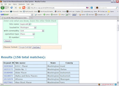
Selecting "Google Earth" in the "Choose format:" drop-down box and clicking the "Get Data" button brings up the data download screen.
I elected to download the .kmz compressed data file although the full size .kml file would work just as well.
With the data file safely tucked away on my hard disk, I open World Wind and go to "File" > "Import KML/KMZ file..." and select the data file I downloaded and saved in the previous steps.
I next navigate to an area that interests me...in this case, Cashmere, Washington, just west of Wenatchee.
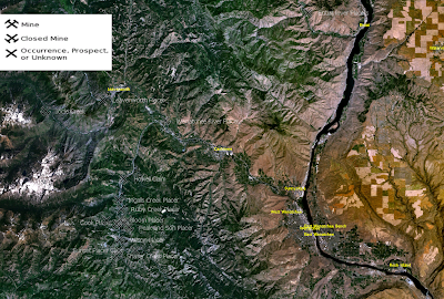
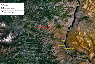
The image above is the basic World Wind view without overlays. As with Google Earth, mineral occurrences are denoted with "X-like" symbols. A couple of differences with Google Earth are that, 1) the name of the mineral occurrence appears next to the symbol, and 2) clicking on a symbol does NOT -- at least on my system -- open an information bubble.
For this example, lets look at the "Wenatchee River Placer" (underlined in red on the image below).
Perhaps the most useful overlay available in World Wind is "USGS Topo Maps." Zooming in on the Wenatchee River Placer and selecting this overlay results in the following image.
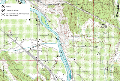
The Topo Map view is useful as it identifies features that are not so easily recognized on the aerial views of Google Earth.
Another World Wind overlay is "USGS Digital Ortho Photos" which, while not as detailed as Google Earth's high resolution color images, may still contain useful information. Below is the same view as the previous one, only with the Ortho Photo overlay enabled.
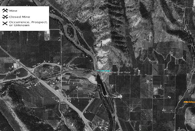
Next is a closer look at the Wenatchee River Placer with the Ortho Photo overlay.
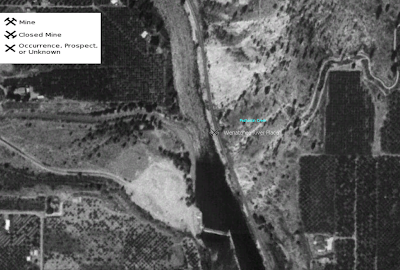
And finally, for comparison, here is the Wenatchee River Placer as seen in Google Earth.
While the Google Earth pictures are more detailed, World Wind displays uniquely useful information via the topographic map overlays. Both of these Earth imaging applications can be combined with the USGS Mineral Resources Data System to identify areas worthy of further study in the search for valuable minerals.
I hope the foregoing posts contribute to both your enjoyment of and success at mineral prospecting.
Thursday, November 26, 2009
Armchair Prospecting with Google Earth
"Armchair prospecting," as I use the term, is a relatively recent method of researching potential mineral deposits using Internet technology such as Google Earth (free at the link here) in conjunction with some of the data resources linked in this blog. Below is an example illustrating how I go about using this method to locate potential gold placer locations.
The following directions are for using Google Earth on a Windows XP computer.
Under "Resources for Prospectors" in the right-hand sidebar of this blog, I locate the link for USGS Mineral Resources On-Line Spatial Data. Clicking on this link takes me to the "Mineral Resources On-Line Spatial Data" main page. Under the heading "Mineral resource data" there is a link titled Mineral Resources Data System (MRDS). Following this link takes me to a page with links to the data files for various mineral resources.
Scrolling down the page to the "Download" section, I find links for downloading data by geographic areas or by "site name, US state, or commodity." Since I'm interested in finding occurrences of gold in Washington, I click on the latter link.
This action takes me to the "Search the Mineral Resources Data System" page where there is a search form containing a number of input and drop-down boxes. I select "Washington" in the "located in" drop-down box and "Gold" in the "with commodity" drop-down box. Clicking the "Search" button, I'm taken to a page which has the same search form and below it a box with the legend, "Choose format." I select "Google Earth" in the drop-down box and click the "Get Data" button.
I'm now taken to a page titled "Package data in KML (for Google Earth) format." There is a box with links for downloading either the full-size "mrds-Washington-Gold-0.kml" file of 5.9 MB or the compressed .kmz version of 189.4 KB. Since either the .kml or .kmz file will work in Google Earth, I choose to download the smaller one (which saves download time and disk space) by clicking the link for the "Compressed data file."
With the data file safely downloaded and saved to a known location on the hard disk, all I need to do is open Google Earth. When it has loaded and is running, I click "File">"Open" and navigate to the the location of the recently downloaded data file. I next select the file (called "mrds-Washington-Gold-0.kmz") and open it. When the file loads, a large number of "X-like" symbols appear over the map of Washington state. According to the legend in the lower left corner of the image, these symbols represent either a "Mine", "Closed Mine", or "Occurrence, Prospect, or Unknown" deposit of the mineral in question -- in this case, gold.
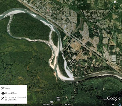
For this example, I choose to center the Google Earth view on Index, a small town in southeastern Snohomish County. Since I'm looking for placer locations, I focus my attention on one of the Xs (that I've circled in red) on the left side of the image below on the Skykomish River near Gold Bar.
Zooming in on my selected symbol, I can see that there are a number of gravel bars on the river in this area.
Any of these bars would be likely spots to try for placer gold. Of course, I would need to determine if there is public access or else arrange permission from private property owners in order to get to the river. I would also need to determine if the locations I am considering are under active mining claim and, if I am interested in staking a claim of my own, find out if the location is open to mineral entry.
If I click on the "X" symbol on my map, I get a pop-up box that contains more information on this particular site, as shown below.
Inside this pop-up box is a link to the record for this site. Clicking on this link will take me to a web page with whatever additional information may be available for this mineral occurrence.
Although the location of this example lies in a relatively developed area, the same method can be used to explore remote wilderness locations.
I hope you have learned something useful from this post and wish you happy "armchair prospecting" sessions this winter that lead to fruitful outdoor expeditions with the return of warmer weather.
Wednesday, November 25, 2009
NWMA Director Challenges SOMA Mining Rights Interpretation
As you may recall from a previous post on this blog, the understanding this writer received of the argument put forth by Hal Anthony, SOMA Vice President Ron Gibson, etc. was that the "uncommon minerals" (e.g. gold, silver, etc.) were given by Congress to the people by the Act of 1866 and that the terms of this grant of property are such that it cannot be terminated or restricted by any subsequent act of Congress or act of any state legislature.
Laura Skaer argues, on the other hand, that mining rights are subject to regulation as provided for in the Mining Law of 1872. Jorgensen quotes Skaer in his article as saying, “The 1872 Mining Law specifically provides that a citizen’s right to explore, occupy and purchase valuable mineral deposits in lands belonging to the United States is specifically subject to regulations prescribed by law.” (Emphasis added -- Tom)
The relevant language from the 1872 law would appear to be, "...all valuable mineral deposits in lands belonging to the United States, both surveyed and unsurveyed, shall be free and open to exploration and purchase, and the lands in which they are found to occupation and purchase, by citizens of the United States and those who have declared their intention to become such, under regulations prescribed by law...." Similar language appears in the Act of 1866: "That the mineral lands of the public domain, both surveyed and unsurveyed, are hereby declared to be free and open to exploration and occupation by all citizens of the United States, and those who have declared their intention to become citizens, subject to such regulations as may be prescribed by law...."
Although not an expert in legal matters, it seems to this writer that the question revolves around whether the phrase "under regulations prescribed by law" refers to the procedures for "occupation and purchase" of mineral lands or to the right to explore, occupy and purchase mineral lands. In any event, there is clearly a need in the mining community for a knowledgeable clarification of the federal mining laws in this regard. One hopes that such clarification will not be long in coming.
You may read the IVN article by Scott Jorgensen at the link here.
Tuesday, November 17, 2009
California's Suction Dredging Ban Appears Headed for Federal Court
According to this report:
“We are seriously considering a preliminary injunction,” said attorney David Young, who has filed a lawsuit against the state on behalf of Public Lands for the People.
The newspaper points out that SB 670 "invalidated approximately 3,624 mining permits around the state and made suction dredge mining a misdemeanor...." The injunction is being sought on the grounds that the state has infringed on miners' federally granted property rights.
For more information, read the complete article at the link here.
Tuesday, November 3, 2009
Oregon Miner Found Guilty
I shall endeavor to keep readers abreast of any further developments in this case as its implications are likely to be important for all small-scale miners and prospectors.
Tuesday, October 13, 2009
Hal Anthony on KAJO's Wednesday Morning Talk Show with Scott Jorgensen on October 7
There is a lot of information and clarification about the 1866 Act in this one-hour program which may be heard by clicking on the link below:
http://www.kajo.com/features/talk_shows/programs/kajo091007.mp3
Monday, October 5, 2009
Another Hal Anthony Program Related to the Meeting with Sheriff Gil Gilbertson
I have not had a chance to listen to this broadcast and likely will not have a chance for several days. But, for those who are following this story and want the latest information, this most recent episode may be heard by going to this link, clicking on the "Behind the Woodshed" link, locating in the resulting list the two 1-hour segments titled Gil Gilbertson Progress In Mining Meeting Hr1 and Gil Gilbertson Progress In Mining Meeting Hr2, and clicking on the "play" buttons in the leftmost column.
If I can get .mp3 links to these program segments, as I did for the first two programs, I will furnish those in a separate post.
Gil Gilbertson is the Sheriff of Josephine County, Oregon, mentioned in the first two programs by Hal Anthony which are linked in my previous posts referenced in the first paragraph above.
Links to the Text of the Mining Law of 1866
Mining Law of 1866 - Original Document at the Library of Congress
Mining Law of 1866 - Link to Downloadable Copy
Read...study...learn.
Friday, October 2, 2009
New Hal Anthony Radio Show on 1866 Mining Law
On September 30, Hal Anthony broadcast a follow-up program on Revolution Broadcasting which re-iterated the information in the original broadcast and provided some scant update on the situation. Re-iterated were the points that the law of 1866 is "fundamental" and "above and apart from every other law" and that when enacted the 1866 legislation became property so that the miners' assertions of their rights is about property rather than about law. Updated is the fact that Hal Anthony states he has received a copy of the email that Sheriff Gilbertson sent to his deputies instructing them not to interfere with mining operations in Josephine County, Oregon, but that he has not yet received a copy of the memo the Sheriff said he "could" send to the BLM and Forest Service.
You may listen to this broadcast in two segments by visiting the links below:
Hour 1: http://lamp.
Hour 2: http://lamp.
Tuesday, September 29, 2009
IMPORTANT: Internet Broadcast Covers 1866 Property Grant to Miners and Its Present Day Ramifications
The incident which led up to this radio program was the arrest on September 9 of Gold Hill, Oregon, gold miner Clifford R. Tracy for working his claim in alleged violation of U. S. Forest Service regulations. (See stories here and here.) This incident led to a meeting on September 25 between broadcaster Hal Anthony, David McAllister, President of the Southwest Oregon Miners Association, Ron Gibson, Vice President of the Southwest Oregon Miners Association, and a number of media personnel on the one hand, and Josephine County, Oregon, Sheriff Gil Gilbertson on the other. According to the broadcast report of this meeting, after being shown the 1866 Grant and supporting federal and state laws, Sheriff Gilbertson agreed to instruct his deputies not to interfere with the miners and stated that he could also send a memo to both the BLM and the Forest Service appraising them of this development. The Sheriff promised a copy of this memo to Hal Anthony who stated he will make it available to the mining community once he receives it.
You may listen to this broadcast in two segments by visiting the links below:
Hour 1:http://lamp.
Hour 2: http://lamp.
A resource, courtesy of Hal Anthony's broadcast, which provides more information on this subject is the website Our Backyard. Here one can find, among other treasures, the text of the 1866 mineral estate grant, the wording of which is reflected in the General Mining Law of 1872 (US Code Title 30 Chapter 2), which incorporated provisions of both the 1866 and 1870 mining laws, to wit:
§ 22. Lands open to purchase by citizens
Except as otherwise provided, all valuable mineral deposits in lands belonging to the United States, both surveyed and unsurveyed, shall be free and open to exploration and purchase, and the lands in which they are found to occupation and purchase, by citizens of the United States and those who have declared their intention to become such, under regulations prescribed by law, and according to the local customs or rules of miners in the several mining districts, so far as the same are applicable and not inconsistent with the laws of the United States. (Emphasis added.)
I urge all of you to listen to the entire program and learn as much as possible about our actual rights as miners on the public domain. Moreover, this information needs to be distributed as far and as widely as possible, both within the mining and law enforcement communities, in order that serious misunderstandings may be avoided.
Those having further information or clarifications of this subject are invited to share the same via the "comments" section below this post.
New Geologic Map and Data Supplement for Snoqualmie 7.5-Minute Quadrangle Available
Geologic Map GM-75. Geologic map of the Snoqualmie 7.5-minute quadrangle, King County, Washington, by J. D. Dragovich, H. A. Littke, M. L. Anderson, Renate Hartog, G. R. Wessel, S. A. DuFrane, T. J. Walsh, J. H. MacDonald Jr., J. F. Mangano, and Recep Cakir. 2009. Two 36 x 42 in. color sheets, scale 1:24,000. (Plotted; $38.61, including shipping and handling. Sold through the Washington Department of Printing. Also available online at http://www.dnr.wa.gov/
Open File Report 2009-4. Geochemistry, geochronology, and sand point count data for the Snoqualmie 7.5-minute quadrangle, King County, Washington, by J. D. Dragovich, H. A. Littke, J. H. MacDonald Jr., S. A. DuFrane, M. L. Anderson, G. R. Wessel, and Renate Hartog. 2009. 3 Microsoft Excel files with 35 p. text. (Available online only, at http://www.dnr.wa.gov/
Paper copies of map GM-75 may be ordered from the Washington State Department of Printing online General Store.
Sunday, August 9, 2009
New Washington Geologic Maps Available Online
Open File Report 2009-5. Geologic map of the Lake Wooten 7.5-minute quadrangle, Mason County, Washington, by R. E. Derkey, N. J. Hehemann, and Katelin Alldritt. 2009. 35 x 36 in. color sheet, scale 1:24,000. (Available online only, at http://www.dnr.wa.gov/Publications/ger_ofr2009-5_geol_map_lakewooten_24k.pdf [13.2 MB].)
Open File Report 2009-6. Geologic map of the Mason Lake 7.5-minute quadrangle, Mason County, Washington, by R. E. Derkey, N. J. Hehemann, and Katelin Alldritt. 2009. 35 x 36 color sheet, scale 1:24,000. (Available online only, at http://www.dnr.wa.gov/Publications/ger_ofr2009-6_geol_map_masonlake_24k.pdf [18.3 MB].)
Open File Report 2009-7. Geologic map of the Belfair 7.5-minute quadrangle, Mason, Kitsap, and Pierce Counties, Washington by Michael Polenz, Katelin Alldritt, N. J. Hehemann, I. Y. Sarikhan, and R. L. Logan. 2009. 45 x 36 in. color sheet, scale 1:24,000. (Available online only, at http://www.dnr.wa.gov/Publications/ger_ofr2009-7_geol_map_belfair_24k.pdf [23.0 MB].)
Open File Report 2009-8. Geologic map of the Burley 7.5-minute quadrangle, Kitsap and Pierce Counties, Washington, by Michael Polenz, Katelin Alldritt, N. J. Hehemann, and R. L. Logan. 2009. 41 x 36 in. color sheet, scale 1:24,000. (Available online only, at http://www.dnr.wa.gov/Publications/ger_ofr2009-8_geol_map_burley_24k.pdf [17.9 MB].)
The above information was kindly supplied by the Washington Division of Geology and Earth Resources.
Friday, August 7, 2009
California Bans Suction Dredge Mining -- Effective Immediately
According to the California Department of Fish and Game website, the moratorium on suction dredge mining will remain in effect for at least two years while the department completes a court-ordered review of the permit process and makes any necessary changes to the pertinent regulations. Not only are all current dredging permits no longer valid, but permit holders will apparently not be eligible for refunds of fees paid, according to the DFG statement.
In the meantime, running a dredge in a California stream can net you up to a $1,000 fine and six months behind bars.
Those interested may read the notice from the California DFG at the link here.
Countering the California development, Public Lands for the People is preparing a Federal Injunction to stop implementation of the moratorium. Donations for legal fees are requested at the web link above.
Monday, August 3, 2009
Article Exposes Pitfalls of Proposed Federal Mining Legislation
Yesterday, however, there was a refreshing editorial at denverpost.com by Vincent Carroll which tells the other side of the story. Of course, the people who most need to know the facts presented by Mr. Carroll are not the ones reading this blog and, judging by the one comment below the article at the time I read it, at least some of those who need those facts are failing to grasp them still. In any case, it's nice to know that the truth is out there where those who need it may yet discover it and thereby help avert a calamity brought about by unwise mining legislation.
Read the Carroll piece for yourself at the link here.
Monday, July 13, 2009
WDFW Calls for Public Input on Selection of New Director
From the news release:
"We'd like to hear from anglers, hunters and everyone interested in the future of our state's natural resources," said Miranda Wecker, who chairs the nine-member citizen commission responsible for setting policy - and hiring a director - for WDFW. "We'll consider those responses as we get down to the business of selecting a new director."
Perhaps this is an opportunity to move WDFW toward a more small-scale-miner-friendly orientation?
Friday, July 10, 2009
New Geologic Map for Yakima County Area Available
The map, Geologic Map GM-74 (36 x 38 in. color sheet, scale 1:24,000, with 12 p. text), is available through the Washington Department of Printing (http://www.prt.wa.gov/) for $23.48, including shipping and handling, or for free by download as a .pdf file from the link below:
http://www.dnr.wa.gov/Publications/ger_gm74_meekstable_nile_24k.zip [16.0MB]
The data supplement, Open File Report 2009-3, is only available online as a Microsoft Excel file at the link below:
http://www.dnr.wa.gov/Publications/ger_ofr2009-3_meekstable_nile_suppl.xls [4.4MB]
Saturday, June 13, 2009
Recruitment Begins For New WDFW Director
The announcement states that no closing date for the position has yet been set and that an initial review of applications will begin on June 24. Once hired, the new director is expected to commence duties in October.
You may read the original press release at the link here.
Friday, June 12, 2009
Finally! An Editorial In Support Of Suction Dredging
At least one newspaper (albeit in California: The Union of Grass Valley) has published an editorial in support of suction dredging and countering the lies of the environmentalists. It would be nice if more newspapers...especially those here in Washington...would do the same.
You can read the article by James L. Butler, Other Voices: Fish, dredging and mercury — a second opinion, at the link here.
Sunday, April 5, 2009
Washington Gold Prospecting (and Prospectors) in the News
The first is from KING 5 News in Seattle and is titled Gold panning making a comeback. The article states that, "For the first time in a decade, panning for gold in Washington State is considered legal." While not strictly true (under the 1999 rules you could pan almost anywhere all year except in streams, where panning was allowed only during specified "work windows,") the message to the public is clear: Washington's streams are now essentially wide open to anyone with a gold pan. The story quotes Greg Christensen and Robert Cunningham of Bellingham and includes a video clip.
Read and view at the link here.
The second is from the Times Online and bears the headline New gold rush sweeps across America. The article cites the increase in interest in gold prospecting due to gold's rising price and the economic downturn. It mentions Washington State in particular and quotes GPAA general manager Ken Rucker and placer claim owner Ron Larson of Kent.
You can find this second report at the link here.
Friday, April 3, 2009
More Washington Geologic Maps Available Online
The Washington Division of Geology and Earth Resources has announced that all of the 1:100,000-scale geologic maps which they publish, as well as many at other scales, are now available for download from the following link:
http://www.dnr.wa.gov/ResearchScience/Pages/PubMaps.aspx
Many of the maps not available from DGER can be found using the search functions of the USGS National Geologic Map Catalog at the link below:
http://ngmdb.usgs.gov/ngmdb/ngm_quicksearch.html
Happy prospecting!
Thursday, April 2, 2009
Corrected Gold and Fish Pamphlet and Mining Brochure Now Available From WDFW
Titled, Small Scale Mineral Prospecting and Placer Mining in Washington, the two-page brochure is available for download as a .pdf document at the link here.
Friday, March 27, 2009
Washington Land Grabs in the News
The article quotes Reichert as saying, "It’s the idea of bipartisanship and working together to make this an area that all of us can enjoy. It (d)oesn’t matter what party you belong to, protecting our wilderness is important to all of us." (Emphasis added -- Tom)
True to the parameters of Orwellian Newspeak, it is obvious that "all of us" does not include ALL of us. But, I digress.
Apparently, this new bill would widen the boundaries of the existing Alpine Lakes Wilderness, expanding the area that (not) ALL of us can enjoy into lower elevations along the Snoqualmie and Pratt Rivers.
The article also quotes a John Chelminiak, identified as the North Cascades Initiative Director for the Wilderness Society, saying, "It will be a spectacular place to take your children and experience wilderness without having to go to the top of a peak, almost virtually in the backyards of the communities of the North Cascades."
How much longer before these land grabs actually take our backyards?
The bill, known as H.R. 1769, "To expand the Alpine Lakes Wilderness in the State of Washington, to designate the Middle Fork Snoqualmie River and Pratt River as wild and scenic rivers, and for other purposes," is currently in the House Committee on Natural Resources. Although the bill is listed on Thomas, the text is not yet available from the Government Printing Office. The companion bill in the Senate is S. 721 for which, at this point, almost no information exists in online sources. You might check Thomas or set up an alert on GovTrack if you're interested in further developments of this legislation.
The Public News Service article, by Chris Thomas, can be read at the link here.
On a related note, our Senator Murray is also sponsoring a bill, S. 635, that would add 14.3 miles of Illabot Creek in Skagit County lying outside the Glacier Peak Wilderness to the Wild and Scenic Rivers System. This bill, currently without co-sponsors, is in the Energy and Natural Resources Committee of the Senate.
Monday, March 23, 2009
2009 Gold and Fish Pamphlet Available From WDFW
The link to the .pdf file for the new pamphlet is here. You may download and print the pamphlet from this link or order it from one of the WDFW offices listed here.
In addition, the WDFW Habitat Permits & Regulations web page has moved to a new address which is linked here.
Both of these new links have been added to the right-hand sidebar: the 2009 Gold and Fish Pamphlet under "Prospecting & Mining Regulations" and the Habitat Permits & Regulations page under "Resources for Prospectors."
As the new regulations will not take effect until April 3, the current 1999 pamphlet is still available for download at the link here and in the "Prospecting & Mining Regulations" section of the right-hand sidebar until April 3.
Friday, March 13, 2009
WDFW Establishes New Habitat Conservation Working Group
The WDFW press release, citing information provided by Greg Hueckel, assistant director of WDFW's habitat program, states that the new group "will consist of up to 24 advisors who will provide guidance on the development of a conservation plan to protect sensitive fish and shellfish species potentially affected by hydraulic project activities."
“We’ve contacted a variety of interest groups and individuals to make sure the new committee reflects all points of view as we develop this important plan," the release quotes Hueckel as saying. It then goes on to report that "(I)nvitations have been sent to tribal representatives, businesses, government agencies and environmental organizations."
Owing to WDFW requirements that prospectors and miners possess hydraulic project approval before commencing activities, one wonders if they will also be represented on the new committee?
The group is slated to start work this spring and is expected to continue for two years. The deadline for nominations is April 1. Nominations may be directed to Carol Piening, Washington Department of Fish and Wildlife, Habitat Program, 600 Capitol Way N., Olympia, WA 98501-1091. Or by email to carol.piening@dfw.wa.gov.
Further information is available from the WDFW press release at the link here.
Friday, February 20, 2009
New Geologic Maps Available
Geologic Map GM-68. Geologic map of the Camano 7.5-minute quadrangle, Island County, Washington, by Michael Polenz, H. W. Schasse, M. L. Kalk, and B. B. Petersen. 2009. 48 x 36 in. color sheet, scale 1:24,000. (Plotted; $22.18, including shipping and handling. Sold through the Washington Department of Printing. Also available online at http://www.dnr.wa.gov/Publications/ger_gm68_geol_map_camano_24k.pdf [10.1 MB].)These maps may be either downloaded from the links above or printed copies ordered from the Washington Department of Printing.
Geologic Map GM-69. Geologic map of the Langley and western part of the Tulalip 7.5-minute quadrangles, Island County, Washington, by H. W. Schasse, M. L. Kalk, B. B. Petersen, and Michael Polenz. 2009. 47 x 36 in. color sheet, scale 1:24,000. (Plotted; $22.18, including shipping and handling. Sold through the Washington Department of Printing. Also available online at http://www.dnr.wa.gov/Publications/ger_gm69_geol_map_langley_24k.pdf [10.1 MB].)
Geologic Map GM-70. Geologic map of the Juniper Beach 7.5-minute quadrangle, Island County, Washington, by H. W. Schasse, M. L. Kalk, and Michael Polenz. 2009. 39 x 36 in. color sheet, scale 1:24,000. (Plotted; $22.18, including shipping and handling. Sold through the Washington Department of Printing. Also available online at http://www.dnr.wa.gov/Publications/ger_gm70_geol_map_juniperbeach_24k.pdf [11.5 MB].)
Geologic Map GM-71. Geologic map of the Olsen Canyon 7.5-minute quadrangle, Lincoln and Stevens Counties, Washington, by R. E. Derkey and M. M. Hamilton. 2009. 42 x 36 in. color sheet, scale 1:24,000. (Plotted; $22.18, including shipping and handling. Sold through the Washington Department of Printing. Also available online at http://www.dnr.wa.gov/Publications/ger_gm71_geol_map_olsencanyon_24k.pdf [14.7 MB].)
Geologic Map GM-72. Geologic map of the Maytown 7.5-minute quadrangle, Thurston County, Washington, by R. L. Logan, T. J. Walsh, B. W. Stanton, and I. Y. Sarikhan. 2009. 42 x 36 in. color sheet, scale 1:24,000. (Plotted; $22.18, including shipping and handling. Sold through the Washington Department of Printing. Also available online at http://www.dnr.wa.gov/Publications/ger_gm72_geol_map_maytown_24k.pdf [30.3 MB].)
Geologic Map GM-73. Geologic map of the North Bend 7.5-minute quadrangle, King County, Washington, with a discussion of the major faults, folds, and basins in the map area, by J. D. Dragovich, T. J. Walsh, M. L. Anderson, Renate Hartog, S. A. DuFrane, Jeff Vervoot, S. A. Williams, Recep Cakir, K. D. Stanton, F. E. Wolff, D. K. Norman, and J. L. Czajkowski. 2009. 38 x 36 in. color sheet, scale 1:24,000, with 39 p. text. (Plotted; $23.48, including shipping and handling. Sold through the Washington Department of Printing. Also available online at http://www.dnr.wa.gov/Publications/ger_gm73_geol_map_northbend_24k.zip [44.7 MB].)
For more information on Washington geologic publications, visit the link here.
Wednesday, February 11, 2009
Beach Mining Pilot Program Update
Thanks to the kindness of Lisa Lantz, Resource Stewardship Manager for the SW Region of Washington State Parks, who supplied a copy of an update report prepared for the Parks Commission on January 22 last, we now have some insight on what has been happening behind the scenes.
According to the report, beginning in May, 2008, State Parks personnel met with WDFW and selected three areas where prospecting would be allowed: "Long Beach – from Ocean Park Ocean Beach Access (OBA) to Klipsan OBA; South Beach – from Bonge OBA to Grayland OBA; and North Beach – from Ocean City OBA to Oyehut OBA."
Subsequently, State Parks received comments that the prospecting areas selected failed to provide freshwater access for miners. As a result, State Parks, in consultation with WDFW, "opened the Iron Springs area, a one-half mile stretch of North Beach, centered on the mouth of Boone Creek," in December.
It should be noted that all participants in the pilot project are required to obtain an HPA from WDFW. Information on applying for an HPA is available from the WDFW web page here. On-line forms and instructions may be found at the One-Stop JARPA Resource Center.
Originally, WDFW limited the equipment miners could use to "motorized pans, non-motorized pans, sluice boxes, mini rocker boxes and non-motorized concentrators." This list was subsequently expanded to include:
Pans; Spiral wheels; Sluices, concentrators, mini rocker boxes, rocker boxes, mini high-bankers with riffle areas totaling 3 square feet or less, including ganged equipment, and high-bankers with riffle areas totaling 10 square feet or less, including ganged equipment; Suction dredges with suction intake nozzle inside diameters no greater than 5-1/4 inches. The inside diameter of the dredge hose attached to the nozzle may be no greater than one inch larger than the suction intake nozzle size; Power sluice/suction dredge combinations with riffle areas totaling 10 square feet or less, including ganged equipment; suction intake nozzle inside diameters no greater than 5-1/4 inches; and pump intake hose inside diameters no greater than 4 inches. The inside diameter of the dredge hose attached to the suction intake nozzle may be no greater than one inch larger than the suction intake nozzle size; and, High-bankers and power sluices with riffle areas totaling 10 square feet or less, including ganged equipment, and pump intake hoses with inside diameters of 4 inches or less.
Furthermore, when miners receive their HPAs, they "also receive maps of the pilot areas and a letter from Parks requesting their cooperation in collecting basic information on the pilot project," including, "where each mining activity occurs, the number of people participating, number of days per activity, quantity of material removed from the beach, type of equipment used, and any difficulties encountered." Miners are also required to "notify WDFW and Parks staff prior to starting work."
According to the report, as of December, 48 people had registered in the North Beach area. The other areas had no reported activity.
For those interested in reading it, the update report for the Parks Commission is available the the link below:
Placer Mining Pilot Program Report.pdf
Monday, February 9, 2009
Radio Program to Discuss Mining Act Tonight
This evening
http://www.gcnlive.com/Listen_Live.html
Pick a Live Stream on Network 1
P.S. You can contact Mister Anthony for comments, questions, guest appearances, etc @ markonthebeast@yahoo.com
P.S. This is a call in show, so if there are any questions you or others have to the topic, please call and ask. Please pass this info on far and wide.Given the ugly noises coming out of the current administration and Congress regarding overhaul of the 1872 Mining Law, listening/participating in this broadcast would be a good way to stay informed and educate other listeners.
Thanks, Bruce, for the heads-up.
Monday, February 2, 2009
Ken Salazar on the 1872 Mining Law
The Q & A with Ken Salazar published at denverpost.com contains the following exchange with the new Interior secretary and former U.S. senator from Colorado regarding reform of the 1872 Mining Law:
The Post: Will you push for reform of the 1872 hard-rock mining law?
Salazar: Any law that has been out there for 136 years and has not been changed needs to be looked at. And in my view, the 1872 mining law is archaic in many ways and needs to be brought into modernity. There are lots of places where the environmental community and the mining community could reach consensus, including issues such as the patenting of public lands and the requirement that fair market value be paid for surface lands that are sometimes now patented as, essentially, giveaways.
Friday, January 30, 2009
More on the Current 1872 Mining Law Reform Attempt
Those interested in following the progress of the current bill, H.R. 699, may do so by visiting the link here or by checking the new section in the right-hand sidebar titled Legislative Alerts and utilizing the links there.
Additionally, there is another article on this proposed measure appearing in the San Jose Mercury News which is linked here.
Stay tuned.
Wednesday, January 28, 2009
"Reformers" Target 1872 Mining Law -- Again
According to an article in the Colorado Independent, Democratic Representative Nick Rahall of West Virginia, chairman of the House Natural Resources Committee, plans to introduce the Hardrock Mining and Reclamation Act of 2009. Like its predecessors, this bill would levy "a 4 percent royalty on existing mines and an 8 percent royalty on new mines — percentages that are in line with what the coal, oil and gas industries currently pay."
I'm not even going to go into why metal mines are not comparable to coal, oil, and gas operations and therefore should not be treated on the same basis. The galling thing is that the proponents of this measure seem more interested in the APPEARANCE of fairness than in actual fairness. But I guess that's what we should expect from those who practice extortion for a living.
The article also seems to equate the current "royalty-free extraction of gold, uranium and other hard-rock minerals from public lands across the West" allowed by the General Mining Law of 1872 with a $1.6 billion subsidy over the coming decade. Huh? Isn't this like a mugger who doesn't take ALL of your money claiming that he's given you a financial contribution?
Anyway, for those hypotensive souls out there who need to elevate their blood pressure, you can find the above mentioned article at the link here.
Sunday, January 18, 2009
New "Gold and Fish Pamphlet" Coming (Slowly)
1. Because WDFW will publish a new Gold and Fish pamphlet in April 2009 that incorporates new rules adopted by the Fish and Wildlife Commission on November 8, 2008, WDFW will no longer be printing or distributing copies of the 1999 edition.
2. WDFW is developing the 2009 edition of the Gold and Fish pamphlet and will post it on this page when complete.
Accordingly, you may want to visit "this page" from time to time in order to keep up with the appearance of the new regulations. I shall endeavor to do likewise and post any updates here.
Note (added 1/21/2009): RCW 77.55.091 Small Scale Prospecting and Mining -- Rules states, in part (emphasis added):
(3) Within two months of adoption of the rules, the department shall distribute an updated gold and fish pamphlet that describes methods of mineral prospecting that are consistent with the department's rule....
I was just wondering how this squares with the November 8, 2008 to April something, 2009 time frame for the publication of the new pamphlet? I guess some of us get to play fast and loose with the rules while the rest of us don't?