Sunday, November 29, 2009

More on Armchair Prospecting

For the basics of "Armchair Prospecting," see my previous post at the link here.

Another mapping program that utilizes the Google Earth .kml and .kmz data files is NASA's World Wind 1.4 (available free at the link here). I find World Wind of value for the different types of image overlays it provides. A quick example with illustrations will show what I mean.

Let's say that, as before, I am looking for potential gold placer sites. It is a well known truism that the best places to find gold (or any other mineral) are in areas where it has been found before. Turning to the Mineral Resources Data System discussed in the previous post linked above, I fill out the search box, selecting "Washington" for located in, "Gold" for with commodity, and "Placer" for operation type.


Clicking the "Search" button brings up the results screen.


Selecting "Google Earth" in the "Choose format:" drop-down box and clicking the "Get Data" button brings up the data download screen.


I elected to download the .kmz compressed data file although the full size .kml file would work just as well.

With the data file safely tucked away on my hard disk, I open World Wind and go to "File" > "Import KML/KMZ file..." and select the data file I downloaded and saved in the previous steps.

I next navigate to an area that interests me...in this case, Cashmere, Washington, just west of Wenatchee.


The image above is the basic World Wind view without overlays. As with Google Earth, mineral occurrences are denoted with "X-like" symbols. A couple of differences with Google Earth are that, 1) the name of the mineral occurrence appears next to the symbol, and 2) clicking on a symbol does NOT -- at least on my system -- open an information bubble.

For this example, lets look at the "Wenatchee River Placer" (underlined in red on the image below).


Perhaps the most useful overlay available in World Wind is "USGS Topo Maps." Zooming in on the Wenatchee River Placer and selecting this overlay results in the following image.


The Topo Map view is useful as it identifies features that are not so easily recognized on the aerial views of Google Earth.

Another World Wind overlay is "USGS Digital Ortho Photos" which, while not as detailed as Google Earth's high resolution color images, may still contain useful information. Below is the same view as the previous one, only with the Ortho Photo overlay enabled.


Next is a closer look at the Wenatchee River Placer with the Ortho Photo overlay.


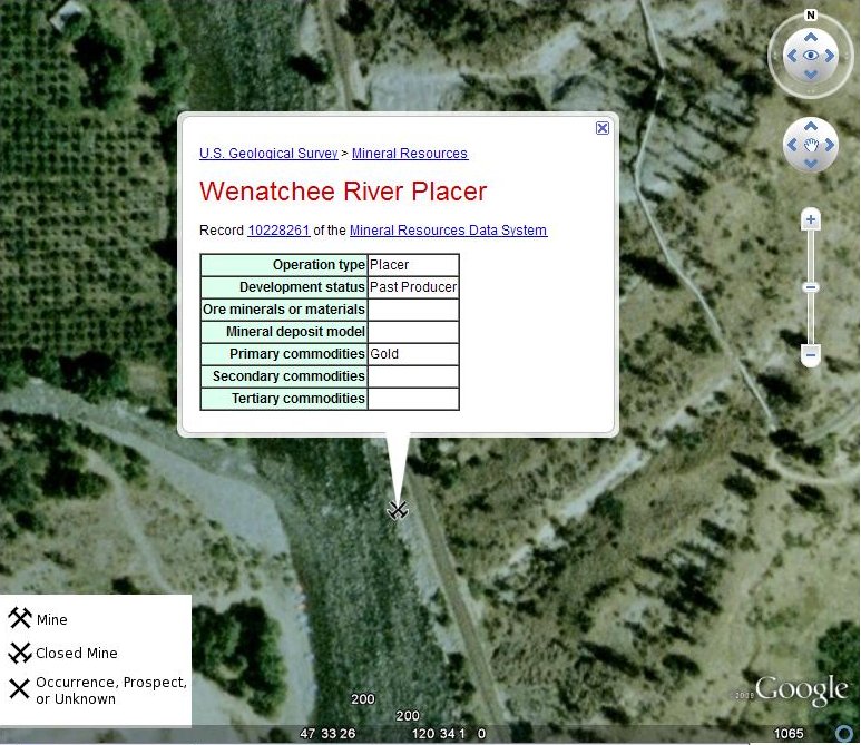
And finally, for comparison, here is the Wenatchee River Placer as seen in Google Earth.


While the Google Earth pictures are more detailed, World Wind displays uniquely useful information via the topographic map overlays. Both of these Earth imaging applications can be combined with the USGS Mineral Resources Data System to identify areas worthy of further study in the search for valuable minerals.

I hope the foregoing posts contribute to both your enjoyment of and success at mineral prospecting.

Thursday, November 26, 2009

Armchair Prospecting with Google Earth

Now that the winter months are upon us and many prospecting regions are inaccessible due to snow, I thought it was time to introduce the topic of "armchair prospecting" to those who may not be familiar with it.

"Armchair prospecting," as I use the term, is a relatively recent method of researching potential mineral deposits using Internet technology such as Google Earth (free at the link here) in conjunction with some of the data resources linked in this blog. Below is an example illustrating how I go about using this method to locate potential gold placer locations.

The following directions are for using Google Earth on a Windows XP computer.

Under "Resources for Prospectors" in the right-hand sidebar of this blog, I locate the link for USGS Mineral Resources On-Line Spatial Data. Clicking on this link takes me to the "Mineral Resources On-Line Spatial Data" main page. Under the heading "Mineral resource data" there is a link titled Mineral Resources Data System (MRDS). Following this link takes me to a page with links to the data files for various mineral resources.

Scrolling down the page to the "Download" section, I find links for downloading data by geographic areas or by "site name, US state, or commodity." Since I'm interested in finding occurrences of gold in Washington, I click on the latter link.

This action takes me to the "Search the Mineral Resources Data System" page where there is a search form containing a number of input and drop-down boxes. I select "Washington" in the "located in" drop-down box and "Gold" in the "with commodity" drop-down box. Clicking the "Search" button, I'm taken to a page which has the same search form and below it a box with the legend, "Choose format." I select "Google Earth" in the drop-down box and click the "Get Data" button.

I'm now taken to a page titled "Package data in KML (for Google Earth) format." There is a box with links for downloading either the full-size "mrds-Washington-Gold-0.kml" file of 5.9 MB or the compressed .kmz version of 189.4 KB. Since either the .kml or .kmz file will work in Google Earth, I choose to download the smaller one (which saves download time and disk space) by clicking the link for the "Compressed data file."

With the data file safely downloaded and saved to a known location on the hard disk, all I need to do is open Google Earth. When it has loaded and is running, I click "File">"Open" and navigate to the the location of the recently downloaded data file. I next select the file (called "mrds-Washington-Gold-0.kmz") and open it. When the file loads, a large number of "X-like" symbols appear over the map of Washington state. According to the legend in the lower left corner of the image, these symbols represent either a "Mine", "Closed Mine", or "Occurrence, Prospect, or Unknown" deposit of the mineral in question -- in this case, gold.

For this example, I choose to center the Google Earth view on Index, a small town in southeastern Snohomish County. Since I'm looking for placer locations, I focus my attention on one of the Xs (that I've circled in red) on the left side of the image below on the Skykomish River near Gold Bar.


Zooming in on my selected symbol, I can see that there are a number of gravel bars on the river in this area.


Any of these bars would be likely spots to try for placer gold. Of course, I would need to determine if there is public access or else arrange permission from private property owners in order to get to the river. I would also need to determine if the locations I am considering are under active mining claim and, if I am interested in staking a claim of my own, find out if the location is open to mineral entry.

If I click on the "X" symbol on my map, I get a pop-up box that contains more information on this particular site, as shown below.


Inside this pop-up box is a link to the record for this site. Clicking on this link will take me to a web page with whatever additional information may be available for this mineral occurrence.

Although the location of this example lies in a relatively developed area, the same method can be used to explore remote wilderness locations.

I hope you have learned something useful from this post and wish you happy "armchair prospecting" sessions this winter that lead to fruitful outdoor expeditions with the return of warmer weather.

Holiday Message to My Readers

HAPPY THANKSGIVING

Wednesday, November 25, 2009

NWMA Director Challenges SOMA Mining Rights Interpretation

According to an article in the Illinois Valley News by writer Scott Jorgensen, Laura Skaer, executive director of the Northwest Mining Association based in Spokane, Washington, issued a letter on October 28 to several Washington state officials challenging the interpretation of mining rights expressed by some members of the Southwest Oregon Mining Association (SOMA).

As you may recall from a previous post on this blog, the understanding this writer received of the argument put forth by Hal Anthony, SOMA Vice President Ron Gibson, etc. was that the "uncommon minerals" (e.g. gold, silver, etc.) were given by Congress to the people by the Act of 1866 and that the terms of this grant of property are such that it cannot be terminated or restricted by any subsequent act of Congress or act of any state legislature.

Laura Skaer argues, on the other hand, that mining rights are subject to regulation as provided for in the Mining Law of 1872. Jorgensen quotes Skaer in his article as saying, “The 1872 Mining Law specifically provides that a citizen’s right to explore, occupy and purchase valuable mineral deposits in lands belonging to the United States is specifically subject to regulations prescribed by law.” (Emphasis added -- Tom)

The relevant language from the 1872 law would appear to be, "...all valuable mineral deposits in lands belonging to the United States, both surveyed and unsurveyed, shall be free and open to exploration and purchase, and the lands in which they are found to occupation and purchase, by citizens of the United States and those who have declared their intention to become such, under regulations prescribed by law...." Similar language appears in the Act of 1866: "That the mineral lands of the public domain, both surveyed and unsurveyed, are hereby declared to be free and open to exploration and occupation by all citizens of the United States, and those who have declared their intention to become citizens, subject to such regulations as may be prescribed by law...."

Although not an expert in legal matters, it seems to this writer that the question revolves around whether the phrase "under regulations prescribed by law" refers to the procedures for "occupation and purchase" of mineral lands or to the right to explore, occupy and purchase mineral lands. In any event, there is clearly a need in the mining community for a knowledgeable clarification of the federal mining laws in this regard. One hopes that such clarification will not be long in coming.

You may read the IVN article by Scott Jorgensen at the link here.

Tuesday, November 17, 2009

California's Suction Dredging Ban Appears Headed for Federal Court

California's moratorium on suction dredge mining, implemented when Governor Schwarzenegger signed SB 670 into law last August, may be challenged in federal court, according to an article by Elizabeth Larson in the Lake County News.

According to this report:

“We are seriously considering a preliminary injunction,” said attorney David Young, who has filed a lawsuit against the state on behalf of Public Lands for the People.

The newspaper points out that SB 670 "invalidated approximately 3,624 mining permits around the state and made suction dredge mining a misdemeanor...." The injunction is being sought on the grounds that the state has infringed on miners' federally granted property rights.

For more information, read the complete article at the link here.

Tuesday, November 3, 2009

Oregon Miner Found Guilty

The case of Gold Hill, Oregon miner Clifford R. Tracy has been mentioned in two previous posts on this blog (here and here) in connection with the 1866 Mining Law. Today we learn that Mr. Tracy has been found "guilty of mining without an operating plan approved by forest officials" by U.S. District Court Judge Owen M. Panner, as reported in this article in the Mail Tribune of Medford, Oregon. According to Mail Tribune reporter Anita Burke, Tracy was sentenced to one year probation. Further details my be found by visiting the article at the link above.

I shall endeavor to keep readers abreast of any further developments in this case as its implications are likely to be important for all small-scale miners and prospectors.