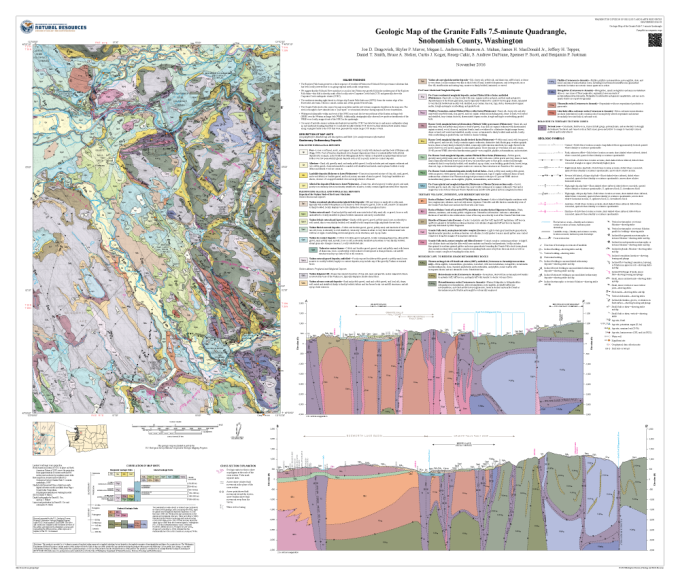
The Washington State Department of Natural Resources has announced the release of a 1:24,000-scale geologic map of the Granite Falls quadrangle.
The new map can be downloaded for free by clicking the map image here.
To see all of the available geologic maps by Washington DNR, visit the link here, which is an online viewer application.


![[Most Recent Quotes from www.kitco.com]](https://lh3.googleusercontent.com/blogger_img_proxy/AEn0k_tlpcYt3SCRNO6ESEdJOyuPIHzvAYDdw7mnocrrt94frgrnskKBBdcIuWbQPUPh3wJHABAouELB5ooP4XfRBCATIZBjXAVLg54Y4NQvkFvGaH2WdJ7qds1EpglxbxMayW3VcQ=s0-d)
![[Most Recent Quotes from www.kitco.com]](https://lh3.googleusercontent.com/blogger_img_proxy/AEn0k_ud9CmEsIYNAu91xP6z0xHbHBFFf37a0wFwZca8OLm8I4TT-FrPbg0qCFTT_K0FQP1nW61fVmhPY8EVTBQQJrGlbTiy_HO8MTyvDCsBUAAtgaWQBn48gFHgDiouWBSVBjv0VW94=s0-d)
![[Most Recent Quotes from www.kitco.com]](https://lh3.googleusercontent.com/blogger_img_proxy/AEn0k_tODKBQH5LOZBC5KrZKCA7UEmCRKU49IigTl8WARhuqoVyvBo-BowzOGDn_l5ZzebVoqam9NalaHlToPrlrKdYkgz53ih-jT6p55vdIoa5qO967D9-KIKg8fM32sa1_U23P7jCeeJs=s0-d)
![[Most Recent Quotes from www.kitco.com]](https://lh3.googleusercontent.com/blogger_img_proxy/AEn0k_tqgFwcQPwFy1SAplP4YNAQGzAGWTELKsDHC-glooKDw7Am0C4oBCNJiHJ7SrqN5rhB7pn-P3ZOTsjAqmE7BR8YxZf4_XSsjp_oqLCdq53RIag2FWq0iKJS-XBdyv5RANKSFcr8DkC9=s0-d)
![[Most Recent Quotes from www.kitco.com]](https://lh3.googleusercontent.com/blogger_img_proxy/AEn0k_tj7WSxJ350PHAyzx4PT0zDbtKvWw9ds8h3AUlNwxyZBatHAFBO1n13MvKvl-3eLL67ti_MR0UL1byA1CGnJC7JlOo5XOMQ1dYnpLwlLkFZwafhduJUU9m3lGk=s0-d)
![[Most Recent Quotes from www.kitco.com]](https://lh3.googleusercontent.com/blogger_img_proxy/AEn0k_uXn2Fvh-XaBQ4GdKMkPpBXr8p3WpIGPh9sDyXjxWWlCkvfDx5IFWU0FTyORkrimUyZut3bTn_S2dF5PWKy6waqZ9WRZHCYPSFcCUE1vvanqRCMdeaW4rX1fVs=s0-d)
![[Most Recent Quotes from www.kitco.com]](https://lh3.googleusercontent.com/blogger_img_proxy/AEn0k_vR2JbWhwSxAwqjyDKCOPC2MwbTtY2_SZpXFPhADuVjW-dPNMh_EJ5AWqbT3NVA44m3TE53qrtwYDLbz4VRykHXAcMukjn6OlElO2Yqb_Fs7f1ZgEi1hboeF0u9Bw=s0-d)
![[Most Recent Quotes from www.kitco.com]](https://lh3.googleusercontent.com/blogger_img_proxy/AEn0k_tvemQ9J88axDpEFlgl3lPgYK2oK5wHCyweOeBXGwT8vlogJ3yr1f45wbiy5SKREsSBce-lhJqOgXjcJOiyNvsSMxmN8x7gD11m27cAMkr2P7kkCKo1TdEQ=s0-d)
![[Most Recent Quotes from www.kitco.com]](https://lh3.googleusercontent.com/blogger_img_proxy/AEn0k_tRJmRvDfij-u8CopzICq41B9jLlKSXXCkPwzGPY3pb66S92OPRdxQtRqVFs5Rw9nw80MgUrLvf0qYvcw5UYM3HqgAqiudKk1xeUDzUQIuq9FbzLruwjEQ=s0-d)