Congressman Kevin McCarthy of California's 22nd District plans to introduce the "Wilderness and Roadless Area Release Act¹” in the near future. The purpose of this legislation is to "release all Wilderness Study Areas and Inventoried Roadless Areas, which have been recommended as not suitable for wilderness by the Bureau of Land Management or the United State(s) Forest Service, and direct that they be managed for multiple use.²" The effect, if this bill becomes law, would be to open more land for prospecting and mining as well as for other public uses.
At present, advocates of this bill are requesting that organizations (not individuals) send an email to Ben McFarland at Congressman McCarthy's office (benjamin.mcfarland@mail.house.gov) asking him to add the organization's name to the list of supporters and to also ask their Congressperson to co-sponsor this legislation. After contacting their Congressperson's office, they can download and send them this "Dear Colleague" letter.
More documentation in .pdf format regarding this bill:
Overview of the bill
Text of the bill
More information as it becomes available.
¹ Forwarded email from Chris Horgan at "Save the Trails"
² Ibid.
Thursday, March 31, 2011
House Committee to Hear Presentation on Beach Mining Pilot Program
The latest development in the long-in-coming opportunity to mine gold at Washington's ocean beaches will be on April 8 before the House Agriculture & Natural Resources Committee. According to the current agenda, this work session will include a "(j)oint presentation by the Department of Fish and Wildlife and the Parks and Recreation Commission on the findings of the Small Scale Mining and Prospecting on Ocean Beaches Pilot Program." As this meeting is not open for public testimony, I mention it here for information only.
For some background on the "Beach Mining Pilot Program," see my earlier posts here, here, and here.
Washington State Miner will continue to follow and report on this story.
For some background on the "Beach Mining Pilot Program," see my earlier posts here, here, and here.
Washington State Miner will continue to follow and report on this story.
Monday, March 21, 2011
MineCache: A Google Earth Plug-in For Gold Prospectors
MineCache is a free plug-in for Google Earth that displays a wealth of information regarding locations where gold has been found in the past. That is to say, those locations where gold is most likely to be found in the present. MineCache displays gold deposit information for the entire United States, including Alaska.
The first step in getting MineCache running on your computer is to download and install Google Earth, which may be done by visiting the link in the first paragraph above and following the on-screen directions.
The next step is to download the MineCache.kml plug-in from the MineCache website linked at the start of this post. With Google Earth running on your computer, visit the download link at MineCache.com and, after registering, follow the instructions there. The MineCache folder will appear in the "Temporary Places" folder in the "Places" section of the left-hand sidebar. (When you exit Google Earth, you will be told you have unsaved items in the "Temporary Places" folder. If you want to keep the MineCache plug-in, click "Save.")
Here is a picture of my "Places" sidebar after installing MineCache (and saving it):

As you may notice, MineCache opens with the options "Auto Refresh," "All Gold Claims - MRDS," and "Zoom in closer" checked.
"Auto Refresh" means that as you move the view-port in Google Earth to a new location, after a second or two the display of gold claims will refresh. If you don't want that to happen by itself, select "Manual Refresh" lower in the list.
"All Gold Claims - MRDS" means that the data displayed is from the USGS Mineral Resource Data System; the same data source discussed in my previous articles on "Armchair Prospecting." In the case of MineCache, the data is pre-selected to show gold deposits only.
"Zoom in closer" means that you are too far out to display any gold locations. Use the zoom-in controls in Google Earth to get closer to the surface. Once you are within 100 miles of the ground, you will see a gold dot moving back and forth under the gold claims folder that is selected. This feature indicates that MineCache is checking for records of gold occurrences in the area of the view-port. When the dot stops moving and turns green, it means that the data search is complete. The "Zoom in closer" legend will be replaced with the number of mines, if any, found. Or, in the case of an area with lots of records, it may tell you to zoom in closer still for more results.
Let's take a look at a typical gold producing area near Blewett Pass in Washington:

Activating MineCache in its default mode (described above) results in the display of 58 locations in which gold was found either as the primary or as a secondary mineral:

More information is available about each of these locations by clicking on an icon in the Google Earth image. For example, if we click on the icon for the Bloom Placer (just above and to the right of the image center), a pop-up box appears with information about the deposit:

If we click on the "View more mine details" link inside the information box, a web page opens in the default browser (in this case, Google Chrome) displaying additional data:

Another feature of MineCache is its ability to display BLM mine claim records for both active and closed mines. These data come from the BLM's GeoCommunicator application and are therefore, as BLM warns, not as complete or accurate as the information provided by the BLM LR2000 site. However, as LR2000 data is not accessible via software while GeoCommunicator data is, it is best to use the MineCache BLM information for initial research on an area and, if the results are promising, go to LR2000 directly for the more up-to-date records.
Selecting "BLM Mine Claim Records - Closed" causes the icons previously displayed to clear and new information to show on the screen:
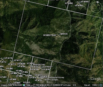
By way of example, clicking on the "Homestead" icon in the center of the screen opens a pop-up box with links to LR2000 information regarding the closed mining claims in this area:

More information about each claim is available by clicking on the "LR2000 MC Report" link for the claim of interest. That is if the link is not broken (as indicated by the red "crosses" at the left end of each data row in the picture) which can happen if LR2000 is down for maintenance or is having some other problem.
Information on active claims is accessed in a similar manner by selecting "BLM Mine Claim Records - Active."
The best procedure is to just install MineCache into your copy of Google Earth and play around with its features. You can also read the tutorial on the MineCache website which gives additional tips and details about the application. The link to the MineCache website is permanently available in the right-hand sidebar of this blog in the section headed "Resources for Prospectors."
Armchair gold prospecting just got a whole lot easier. Have fun!
Friday, March 11, 2011
House Schedules Hearing On HPA Fee Bill (HB 2008)
The companion bill in the House (HB 2008) to the Senate's SB 5862, which was given a public hearing on March 9, is scheduled to be heard before the House General Government Appropriations & Oversight Committee on March 15 at 8:00 A.M. in House Hearing Room C of the John L. O'Brien Building in Olympia.
For background on this set of bills, which would impose some rather stiff fees for Hydraulic Project Approvals outside of the Gold & Fish pamphlet, please refer to my previous post at the link here.
Updates will follow as needed.
For background on this set of bills, which would impose some rather stiff fees for Hydraulic Project Approvals outside of the Gold & Fish pamphlet, please refer to my previous post at the link here.
Updates will follow as needed.
Wednesday, March 2, 2011
WDFW Amends HPA Fee Bill; Hearing Scheduled
UPDATE!
March 4, 2011 at 6:36 P.M.
The hearing on SB 5862 has been rescheduled for March 9 at 8:00 A.M. in Senate Hearing Room 2 of the J. A. Cherberg Building in Olympia. Note that the room number is different from that given for the original hearing.
______________________________
UPDATE!
March 3, 2011 at 3:09 P.M.
The hearing on SB 5862 scheduled for March 4 has been canceled. As far as I am aware, no reason has yet been given. Nevertheless, it would be a good idea to continue contacting legislators with messages in opposition to this bill as otherwise we might be caught napping by events in Olympia.
More information as it becomes available.
______________________________
On February 3 I published a post regarding HB 1588 and its companion bill in the Senate, SB 5529, which together represent WDFW's latest attempt to implement prohibitive fees for mineral prospecting and mining under the Hydraulic Project Approval (HPA) process.
I have now received word that WDFW has "amended" SB 5529 from its original 20 pages to a new 38 page version dubbed SB 5862. (The companion bill in the House is HB 2008.) As I understand it, and I haven't had time to read the entire text of the substitute bill, the additional 18 pages do nothing to improve this proposal from the point of the small-scale mining community.
The reason I haven't, and won't, have time to read this bill before publishing this post is that SB 5862 is scheduled for a public hearing at 8:30 A.M. on Friday, March 4, before the Senate Natural Resources & Marine Waters Committee in Senate Hearing Room 3 of the J. A. Cherberg Building. Therefore, time is of the essence in getting word out about this bill and the coming public hearing.
If you can make it to Olympia on Friday to testify, here are some "talking points*" in favor of abolishing the entire HPA process:
The HPA program:
*Is antiquated, 62 years old
*Prior to 1949, was for the administration of irrigation/water rights.
*Financially burdens the taxpayers of the state through duplication of resources and permits as reported by the HPA Task Force in 2002.
*Financially burdens the taxpayers of the state through continual Legislation and Rule Making.
*Is cumbersome, subjective and unequally applied.
*Has been a subject of legislation for over 11 years.
* In 2008, HB2530, Studying the effectiveness of the existing hydraulic project approval process was introduced but not enacted because of budgetary constraints. This would have directed WDFW to study the effectiveness of the HPA program.
*Is a leading CAUSE of property loss experienced during river high flow or flood events.
*By elimination, will save $9 million dollars. This is a new concept to Legislators and agencies who are looking to increase revenue through the implementation of fee's.
*Has been through "Streamlining" for over 5 years without success. It is time to stop wasting the taxpayers money.
* "Talking points" courtesy of Bill Thomas, President of the Resources Coalition, via email from Bruce Beatty.
Subscribe to:
Posts (Atom)

![[Most Recent Quotes from www.kitco.com]](https://lh3.googleusercontent.com/blogger_img_proxy/AEn0k_vtfzk11SoibI3M1bgjetxzQUNeC6rD7KVAgqYU6oQz_BL4MAT9Hps8-QxBVqDx9IyWaoQXQD-WBvWKkkHnJG6azZLCELmaWC3ckFBX9hItn37uAsCDJI8xWp0Jle7OIJU6cw=s0-d)
![[Most Recent Quotes from www.kitco.com]](https://lh3.googleusercontent.com/blogger_img_proxy/AEn0k_tmJY98olJe_8KhEEdUV71ruQYyALF4ypuCccke_Hu4ZcJPuKWmIW38L7KyWy63WD-ENNTfIrnrZsMbbwqfkkmAUasZ4JnDq6hhwn7NMf-OhFJGLJi54r-CK5_svCeBgEgXgXF_=s0-d)
![[Most Recent Quotes from www.kitco.com]](https://lh3.googleusercontent.com/blogger_img_proxy/AEn0k_saH18xd85OlTZlUUcOt9auLK3MYk-yr6EbtX7Hw6MWHHFMdxBL4t_HzY0CvtrD7QkAkHshFNjsSDPr0AjQiwoha9QWCuKmHBYelQm_4RsunpYFv9e4bFHChkosSSRXyjSTSWZ_WRM=s0-d)
![[Most Recent Quotes from www.kitco.com]](https://lh3.googleusercontent.com/blogger_img_proxy/AEn0k_uyuxBXD3478qD5vdcTNjAOvJHOYHBGUuhFovlV_oivf4dJCRaWr_yd0vhMRUS4kNHL3GBGSW7PiGoM42zIuTUG-qok8JvSCD0TeKpAeZnfbb82-KlAGC_4NhqLj8b7_etBSzXxr6hr=s0-d)
![[Most Recent Quotes from www.kitco.com]](https://lh3.googleusercontent.com/blogger_img_proxy/AEn0k_uHEnMyGMsdLv7-WWbQcF90WbF89RgPVDWCbY3aOVRWkS6XdXlHWQD0h9ne27GxspzIqg1clgUZYBWVz0ov01yF3Gdmq2f7MSLxPqLcjfnlMWK3_8vkAqFfdFE=s0-d)
![[Most Recent Quotes from www.kitco.com]](https://lh3.googleusercontent.com/blogger_img_proxy/AEn0k_uabkfx5EDNdx_RFH3onU1V_f8bLoOfgAXLMQiGQigw69OxenFYSRli3Bea6uoPiRptUv3BHpVJsv6gk8bL-izgkQCNiknzaZSCnO8BSY9Fy8hcsb75a0exikQ=s0-d)
![[Most Recent Quotes from www.kitco.com]](https://lh3.googleusercontent.com/blogger_img_proxy/AEn0k_sQy5gHBcVhLnLXH840cJ-cM64lbjYDlmedCZc2sqkEWbRNulFWB9tKXctJXNfdHz75qIbYbb1myhUXS0luKyH6FYIALaW3DqiTSMjsvS1oy-d6-tAZnh6dda6IqQ=s0-d)
![[Most Recent Quotes from www.kitco.com]](https://lh3.googleusercontent.com/blogger_img_proxy/AEn0k_smC9orGfyOfUCQfsMVJHWOgUgjJrMzIXgoTb6qBebx1oHMFMlLY1LBQdtmG42Nm486iuKnFosu-7GNlwTj6tp-VYPl2IFRA4a-8StRa0uYVrCR0mpblxho=s0-d)
![[Most Recent Quotes from www.kitco.com]](https://lh3.googleusercontent.com/blogger_img_proxy/AEn0k_tNqG2J9hhRsFP7zQKQLlG3DX_5ZCHksF1H22_EJOp9uqLdbDjbH94Xk_ii8LcBvXfSOpXYQwOhJsvMZa4djc0L1MR4wPMH-mCU6uJrGJ9eMmzP2LH7qms=s0-d)