Three bills of interest to miners are scheduled for a public hearing on February 2 at 1:30 pm before the House Full Committee on Agriculture & Natural Resources in House Hearing Room B of the John L. O'Brien Building in Olympia.
Two of these bills have already been discussed on this blog: HB 2597 which would abolish the HPA process entirely (see here, here, and here) and HB 3037 which is a companion bill to SB 6448 and would, among other horrendous things, impose a $100 fee for the Gold & Fish pamphlet (see here and here).
The third bill is HB 2974 which would make some modifications to the enforcement provisions of chapter 77.55 RCW. The meat of this proposed legislation is contained in the following wording:
NEW SECTION. Sec. 1. A new section is added to chapter 77.55 RCW to read as follows:
(1) Concurrent with the initiation of an enforcement action under RCW 77.15.300, 77.55.291, or any other provision of this chapter, and within existing resources, the department must provide the person against whom an enforcement action is being taken with a statement of violation prepared consistent with the requirements of this section.
(2) Any statement of violation prepared under this section must include, at a minimum, the following contents:
(a) A detailed explanation of how the offending project is causing harm to fish life;
(b) Evidence of individual fish actually being harmed by the project, if any, including any documentation of instances of fish mortality linked to the project; and
(c) A signature by a department biologist confirming that the biologist has personally and physically investigated the impacts of the project and attests to the accuracy of the information contained in the statement of violation.
(3) The department may not pursue enforcement against any individual for a violation of this chapter that arises after the effective date of this section unless the statement of violation is provided at the time of the initiation of the enforcement action.
The apparent purpose of this bill is to require enforcement agents to produce evidence of actual harm that has occurred to fish as the result of a project instead of the current system which seems to work along the lines of "we're fining you because we think what you're doing might harm fish." Such a change would be a step in the right direction although it will do little to mitigate the damage to prospecting and mining that will occur if something along the lines of HB 3037/SB 6448 becomes law.
HB 2974 has a substantial number of sponsors in Representatives Orcutt, Herrera, Taylor, McCune, Klippert, Pearson, Kretz, Warnick, and Johnson. You can track progress of this bill at the link here. You can find the text of HB 2974 at the link here and in a link in the Legislative Alerts section of the right-hand sidebar of this blog.
Thursday, January 28, 2010


Wednesday, January 20, 2010
HB 3037 - Companion Bill to SB 6448 - Introduced in the House
I hate to be the bearer of bad news, but SB 6448, the senate bill that would require us to pay a fee of $100 every five years for the priviledge of panning for gold or other minerals (not to mention higher fees for applying for permission to engage in other small-scale mining operations as presented in a previous post), now has a "companion" bill in the state house of representatives: HB 3037.
This latest effort in support of plundering the small-scale miners of Washington state was undertaken by Representatives Jeannie Darneille, (D - Tacoma and Majority Caucus Vice Chair); Dave Upthegrove (D - Kent); Hans Dunshee (D - Lake Stevens); and Zachary Hudgins (D - Seattle and Majority Floor Leader).
I have not read the entire text of this bill (doing so makes me ill) but looking it over it appears to be a near carbon copy of SB 6448. For those who are interested, the document can be accessed at the link in the first paragraph above as well as in .pdf form at the link here and in the "Legislative Alerts" section of the right-hand sidebar of this blog.
Both of these companion bills seem to be getting the big push while HB 2597, which would abolish the whole HPA process, seems to have gotten the shove. Government has to rob somebody to pay for all the wonderful "servicing" we enjoy and it looks like this time our mis-representatives intend for it to be the miners. Unless we can make enough noise to scare the jackels off.
More as it becomes available.
This latest effort in support of plundering the small-scale miners of Washington state was undertaken by Representatives Jeannie Darneille, (D - Tacoma and Majority Caucus Vice Chair); Dave Upthegrove (D - Kent); Hans Dunshee (D - Lake Stevens); and Zachary Hudgins (D - Seattle and Majority Floor Leader).
I have not read the entire text of this bill (doing so makes me ill) but looking it over it appears to be a near carbon copy of SB 6448. For those who are interested, the document can be accessed at the link in the first paragraph above as well as in .pdf form at the link here and in the "Legislative Alerts" section of the right-hand sidebar of this blog.
Both of these companion bills seem to be getting the big push while HB 2597, which would abolish the whole HPA process, seems to have gotten the shove. Government has to rob somebody to pay for all the wonderful "servicing" we enjoy and it looks like this time our mis-representatives intend for it to be the miners. Unless we can make enough noise to scare the jackels off.
More as it becomes available.
Friday, January 15, 2010
New Bill in State Senate Would Devastate Small-Scale Mining
As if to prove the truth of Judge Gideon J. Tucker's observation that "No man's life, liberty or property are safe while the legislature is in session," Senator Ken Jacobsen (D-Seattle) has introduced SB 6448. This particular piece of legislative perversity has a number of "features" that should prove both perplexing and dismaying to the small-scale mining community. A brief summary follows:
Things get going on page 4 with the definition:
(14) "Small scale prospecting and mining" means the use of only the following methods: Pans; nonmotorized sluice boxes; concentrators; and minirocker boxes for the discovery and recovery of minerals.
This definition sort of leaves the status of dredges, highbankers, mini-highbankers and even spiral wheels in limbo.
Page 10 discloses that Section 6 permit fees will take effect on July 1 as per the schedule on page 11:
$100 for a "Pamphlet permit," which fee must be paid every five years.
$250 for an "Application submittal," plus up to
$5,250 for a "Permit processing fee."
$150 for a "Permit modification."
In case there's any doubt, the language on page 15 makes it clear that these fees apply to small-scale mining and prospecting operations:
(4) Permittees conducting activities under authority of pamphlets issued under this section (Sec. 10. RCW 77.55.091 and 2005 c 146 s 402 - Tom) must possess proof of payment of any applicable fees required by section 6 of this act.
Page 10 also discloses that
Unlawfully undertaking hydraulic project activities is a gross misdemeanor.
The civil penalties for daring to dig the queen's gold without proper authorization are described on pages 12 and 13:
Sec. 8. RCW 77.55.291 and 2005 c 146 s 701 are each amended to read as follows:
(1)(a) The department may levy civil penalties of up to one hundred dollars per day ((for violation of any provisions of RCW 77.55.021)) when a person:
(i) Constructs any form of hydraulic project or performs other work on a hydraulic project and fails to have a hydraulic project approval required under this chapter for such construction or work;
(ii) Violates any requirements or conditions of the hydraulic project approval for the construction or work;
(iii) Fails to pay applicable application submittal or permit processing fees within thirty days of receipt of expedited permits or the written follow-up to emergency oral approvals under RCW 77.55.021;35 or
(iv) Violates any rule adopted under RCW 77.55.021, 77.55.081,2 77.55.091, or section of this act that identifies the time, manner, locations, methods, or other conditions under which an activity is approved or not approved.
This bill is scheduled for a public hearing before the full Natural Resources, Ocean & Recreation Committee on 1/20/2010 at 8:00 A.M. in Senate Hearing Room 2 of the J. A. Cherberg Building in Olympia. (In the meantime, HB 2597, discussed in posts here, here, and here and beneficial to miners, languishes in the House Agriculture and Natural Resources Committee.)
Current information on SB 6448 is available at the link near the top of this post. You may also download a .pdf copy of SB 6448 at the link here and at the link in the right-hand sidebar in the "Legislative Alerts" section of this blog.
Things get going on page 4 with the definition:
(14) "Small scale prospecting and mining" means the use of only the following methods: Pans; nonmotorized sluice boxes; concentrators; and minirocker boxes for the discovery and recovery of minerals.
This definition sort of leaves the status of dredges, highbankers, mini-highbankers and even spiral wheels in limbo.
Page 10 discloses that Section 6 permit fees will take effect on July 1 as per the schedule on page 11:
$100 for a "Pamphlet permit," which fee must be paid every five years.
$250 for an "Application submittal," plus up to
$5,250 for a "Permit processing fee."
$150 for a "Permit modification."
In case there's any doubt, the language on page 15 makes it clear that these fees apply to small-scale mining and prospecting operations:
(4) Permittees conducting activities under authority of pamphlets issued under this section (Sec. 10. RCW 77.55.091 and 2005 c 146 s 402 - Tom) must possess proof of payment of any applicable fees required by section 6 of this act.
Page 10 also discloses that
Unlawfully undertaking hydraulic project activities is a gross misdemeanor.
The civil penalties for daring to dig the queen's gold without proper authorization are described on pages 12 and 13:
Sec. 8. RCW 77.55.291 and 2005 c 146 s 701 are each amended to read as follows:
(1)(a) The department may levy civil penalties of up to one hundred dollars per day ((for violation of any provisions of RCW 77.55.021)) when a person:
(i) Constructs any form of hydraulic project or performs other work on a hydraulic project and fails to have a hydraulic project approval required under this chapter for such construction or work;
(ii) Violates any requirements or conditions of the hydraulic project approval for the construction or work;
(iii) Fails to pay applicable application submittal or permit processing fees within thirty days of receipt of expedited permits or the written follow-up to emergency oral approvals under RCW 77.55.021;35 or
(iv) Violates any rule adopted under RCW 77.55.021, 77.55.081,2 77.55.091, or section of this act that identifies the time, manner, locations, methods, or other conditions under which an activity is approved or not approved.
This bill is scheduled for a public hearing before the full Natural Resources, Ocean & Recreation Committee on 1/20/2010 at 8:00 A.M. in Senate Hearing Room 2 of the J. A. Cherberg Building in Olympia. (In the meantime, HB 2597, discussed in posts here, here, and here and beneficial to miners, languishes in the House Agriculture and Natural Resources Committee.)
Current information on SB 6448 is available at the link near the top of this post. You may also download a .pdf copy of SB 6448 at the link here and at the link in the right-hand sidebar in the "Legislative Alerts" section of this blog.
Tuesday, January 12, 2010
HB 2597 Gains New Sponsors
HB 2597, which would abolish the HPA process as reported in a previous post, has two new sponsors.
Representative Kirk Pearson, who introduced the bill, has now been joined by Representatives Judy Warnick and Joel Kretz. Contact information for these three representatives may be found by clicking on their names/links above.
Representative Kirk Pearson, who introduced the bill, has now been joined by Representatives Judy Warnick and Joel Kretz. Contact information for these three representatives may be found by clicking on their names/links above.
Monday, January 11, 2010
Update on HB 2597
HB 2597, the bill in the Washington legislature that would abolish the HPA process as reported on in a previous post, had its first reading today and was referred to the committee on Agriculture & Natural Resources.
More information as it develops.
More information as it develops.
Saturday, January 9, 2010
New Bill in Legislature Would Abolish HPA Process
Washington miner Bruce Beatty has kindly informed this writer of a bill in the Washington state legislature that would eliminate the HPA (Hydraulics Project Approval) process.
HB 2597, titled, "AN ACT Relating to streamlining state environmental permitting through the elimination of the hydraulics project approval process;" was "prefiled for introduction" on January 8 by Representative Kirk Pearson (R) of Index.
Perhaps the key section of the bill of interest to miners is this one:
12 NEW SECTION. Sec. 9. The following acts or parts of acts are each
13 repealed:
...
27 (8) RCW 77.55.091 (Small scale prospecting and mining--Rules) and
28 2005 c 146 s 402 & 1997 c 415 s 2;
The current text of HB 2597 is 15 pages long and may be found on the legislature's website by visiting the link below and clicking the "original bill" link in the "Available Documents" section at the bottom of the page.
http://apps.leg.wa.gov/billinfo/summary.aspx?bill=2597&year=2009
There is also an orange RSS feed link for this bill available on the above page that will allow the subscriber to recieve notices of changes in the bill's status.
In addition, I have provided a link to the .pdf file of the current bill here as well as in the right-hand sidebar under the "Legislative Alerts" heading.
Representative Pearson may be contacted via the information found here.
Washington State Miner will continue to follow this and any related legislation.
HB 2597, titled, "AN ACT Relating to streamlining state environmental permitting through the elimination of the hydraulics project approval process;" was "prefiled for introduction" on January 8 by Representative Kirk Pearson (R) of Index.
Perhaps the key section of the bill of interest to miners is this one:
12 NEW SECTION. Sec. 9. The following acts or parts of acts are each
13 repealed:
...
27 (8) RCW 77.55.091 (Small scale prospecting and mining--Rules) and
28 2005 c 146 s 402 & 1997 c 415 s 2;
The current text of HB 2597 is 15 pages long and may be found on the legislature's website by visiting the link below and clicking the "original bill" link in the "Available Documents" section at the bottom of the page.
http://apps.leg.wa.gov/billinfo/summary.aspx?bill=2597&year=2009
There is also an orange RSS feed link for this bill available on the above page that will allow the subscriber to recieve notices of changes in the bill's status.
In addition, I have provided a link to the .pdf file of the current bill here as well as in the right-hand sidebar under the "Legislative Alerts" heading.
Representative Pearson may be contacted via the information found here.
Washington State Miner will continue to follow this and any related legislation.
Sunday, November 29, 2009
More on Armchair Prospecting
For the basics of "Armchair Prospecting," see my previous post at the link here.
Another mapping program that utilizes the Google Earth .kml and .kmz data files is NASA's World Wind 1.4 (available free at the link here). I find World Wind of value for the different types of image overlays it provides. A quick example with illustrations will show what I mean.
Let's say that, as before, I am looking for potential gold placer sites. It is a well known truism that the best places to find gold (or any other mineral) are in areas where it has been found before. Turning to the Mineral Resources Data System discussed in the previous post linked above, I fill out the search box, selecting "Washington" for located in, "Gold" for with commodity, and "Placer" for operation type.
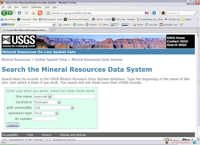
Clicking the "Search" button brings up the results screen.
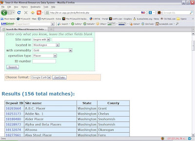
Selecting "Google Earth" in the "Choose format:" drop-down box and clicking the "Get Data" button brings up the data download screen.
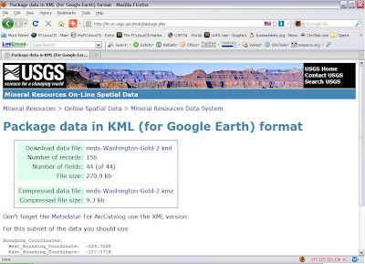
I elected to download the .kmz compressed data file although the full size .kml file would work just as well.
With the data file safely tucked away on my hard disk, I open World Wind and go to "File" > "Import KML/KMZ file..." and select the data file I downloaded and saved in the previous steps.
I next navigate to an area that interests me...in this case, Cashmere, Washington, just west of Wenatchee.
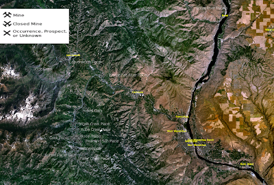
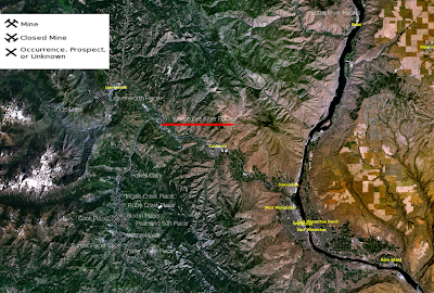
The image above is the basic World Wind view without overlays. As with Google Earth, mineral occurrences are denoted with "X-like" symbols. A couple of differences with Google Earth are that, 1) the name of the mineral occurrence appears next to the symbol, and 2) clicking on a symbol does NOT -- at least on my system -- open an information bubble.
For this example, lets look at the "Wenatchee River Placer" (underlined in red on the image below).
Perhaps the most useful overlay available in World Wind is "USGS Topo Maps." Zooming in on the Wenatchee River Placer and selecting this overlay results in the following image.
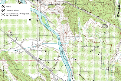
The Topo Map view is useful as it identifies features that are not so easily recognized on the aerial views of Google Earth.
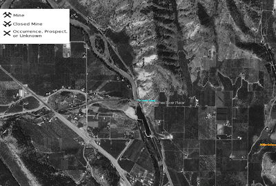
Another World Wind overlay is "USGS Digital Ortho Photos" which, while not as detailed as Google Earth's high resolution color images, may still contain useful information. Below is the same view as the previous one, only with the Ortho Photo overlay enabled.
Next is a closer look at the Wenatchee River Placer with the Ortho Photo overlay.
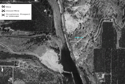
And finally, for comparison, here is the Wenatchee River Placer as seen in Google Earth.

While the Google Earth pictures are more detailed, World Wind displays uniquely useful information via the topographic map overlays. Both of these Earth imaging applications can be combined with the USGS Mineral Resources Data System to identify areas worthy of further study in the search for valuable minerals.
I hope the foregoing posts contribute to both your enjoyment of and success at mineral prospecting.
Another mapping program that utilizes the Google Earth .kml and .kmz data files is NASA's World Wind 1.4 (available free at the link here). I find World Wind of value for the different types of image overlays it provides. A quick example with illustrations will show what I mean.
Let's say that, as before, I am looking for potential gold placer sites. It is a well known truism that the best places to find gold (or any other mineral) are in areas where it has been found before. Turning to the Mineral Resources Data System discussed in the previous post linked above, I fill out the search box, selecting "Washington" for located in, "Gold" for with commodity, and "Placer" for operation type.

Clicking the "Search" button brings up the results screen.

Selecting "Google Earth" in the "Choose format:" drop-down box and clicking the "Get Data" button brings up the data download screen.

I elected to download the .kmz compressed data file although the full size .kml file would work just as well.
With the data file safely tucked away on my hard disk, I open World Wind and go to "File" > "Import KML/KMZ file..." and select the data file I downloaded and saved in the previous steps.
I next navigate to an area that interests me...in this case, Cashmere, Washington, just west of Wenatchee.

The image above is the basic World Wind view without overlays. As with Google Earth, mineral occurrences are denoted with "X-like" symbols. A couple of differences with Google Earth are that, 1) the name of the mineral occurrence appears next to the symbol, and 2) clicking on a symbol does NOT -- at least on my system -- open an information bubble.
For this example, lets look at the "Wenatchee River Placer" (underlined in red on the image below).

Perhaps the most useful overlay available in World Wind is "USGS Topo Maps." Zooming in on the Wenatchee River Placer and selecting this overlay results in the following image.

The Topo Map view is useful as it identifies features that are not so easily recognized on the aerial views of Google Earth.
Another World Wind overlay is "USGS Digital Ortho Photos" which, while not as detailed as Google Earth's high resolution color images, may still contain useful information. Below is the same view as the previous one, only with the Ortho Photo overlay enabled.

Next is a closer look at the Wenatchee River Placer with the Ortho Photo overlay.

And finally, for comparison, here is the Wenatchee River Placer as seen in Google Earth.
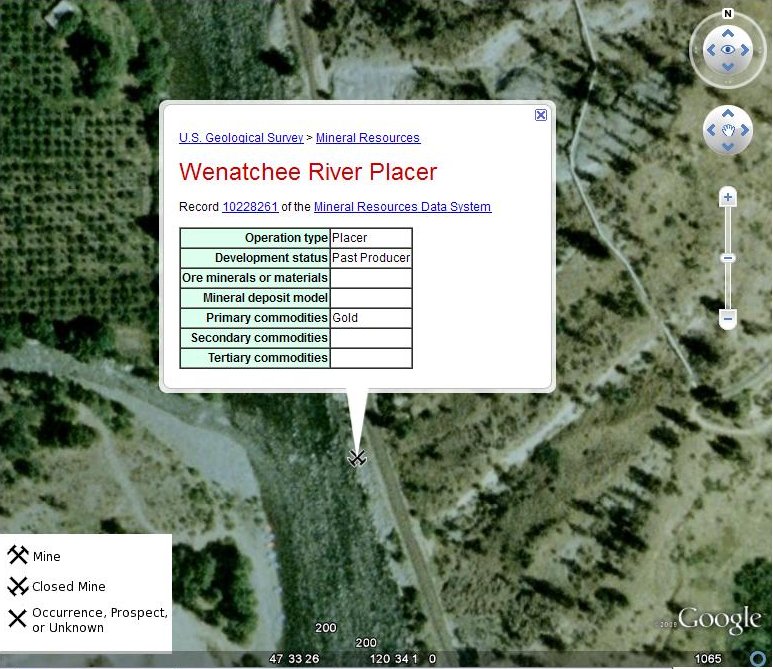
While the Google Earth pictures are more detailed, World Wind displays uniquely useful information via the topographic map overlays. Both of these Earth imaging applications can be combined with the USGS Mineral Resources Data System to identify areas worthy of further study in the search for valuable minerals.
I hope the foregoing posts contribute to both your enjoyment of and success at mineral prospecting.
Thursday, November 26, 2009
Armchair Prospecting with Google Earth
Now that the winter months are upon us and many prospecting regions are inaccessible due to snow, I thought it was time to introduce the topic of "armchair prospecting" to those who may not be familiar with it.
"Armchair prospecting," as I use the term, is a relatively recent method of researching potential mineral deposits using Internet technology such as Google Earth (free at the link here) in conjunction with some of the data resources linked in this blog. Below is an example illustrating how I go about using this method to locate potential gold placer locations.
The following directions are for using Google Earth on a Windows XP computer.
Under "Resources for Prospectors" in the right-hand sidebar of this blog, I locate the link for USGS Mineral Resources On-Line Spatial Data. Clicking on this link takes me to the "Mineral Resources On-Line Spatial Data" main page. Under the heading "Mineral resource data" there is a link titled Mineral Resources Data System (MRDS). Following this link takes me to a page with links to the data files for various mineral resources.
Scrolling down the page to the "Download" section, I find links for downloading data by geographic areas or by "site name, US state, or commodity." Since I'm interested in finding occurrences of gold in Washington, I click on the latter link.
This action takes me to the "Search the Mineral Resources Data System" page where there is a search form containing a number of input and drop-down boxes. I select "Washington" in the "located in" drop-down box and "Gold" in the "with commodity" drop-down box. Clicking the "Search" button, I'm taken to a page which has the same search form and below it a box with the legend, "Choose format." I select "Google Earth" in the drop-down box and click the "Get Data" button.
I'm now taken to a page titled "Package data in KML (for Google Earth) format." There is a box with links for downloading either the full-size "mrds-Washington-Gold-0.kml" file of 5.9 MB or the compressed .kmz version of 189.4 KB. Since either the .kml or .kmz file will work in Google Earth, I choose to download the smaller one (which saves download time and disk space) by clicking the link for the "Compressed data file."
With the data file safely downloaded and saved to a known location on the hard disk, all I need to do is open Google Earth. When it has loaded and is running, I click "File">"Open" and navigate to the the location of the recently downloaded data file. I next select the file (called "mrds-Washington-Gold-0.kmz") and open it. When the file loads, a large number of "X-like" symbols appear over the map of Washington state. According to the legend in the lower left corner of the image, these symbols represent either a "Mine", "Closed Mine", or "Occurrence, Prospect, or Unknown" deposit of the mineral in question -- in this case, gold.
For this example, I choose to center the Google Earth view on Index, a small town in southeastern Snohomish County. Since I'm looking for placer locations, I focus my attention on one of the Xs (that I've circled in red) on the left side of the image below on the Skykomish River near Gold Bar.

Zooming in on my selected symbol, I can see that there are a number of gravel bars on the river in this area.
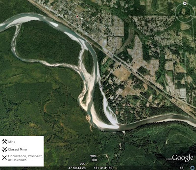
Any of these bars would be likely spots to try for placer gold. Of course, I would need to determine if there is public access or else arrange permission from private property owners in order to get to the river. I would also need to determine if the locations I am considering are under active mining claim and, if I am interested in staking a claim of my own, find out if the location is open to mineral entry.
If I click on the "X" symbol on my map, I get a pop-up box that contains more information on this particular site, as shown below.

Inside this pop-up box is a link to the record for this site. Clicking on this link will take me to a web page with whatever additional information may be available for this mineral occurrence.
Although the location of this example lies in a relatively developed area, the same method can be used to explore remote wilderness locations.
I hope you have learned something useful from this post and wish you happy "armchair prospecting" sessions this winter that lead to fruitful outdoor expeditions with the return of warmer weather.
"Armchair prospecting," as I use the term, is a relatively recent method of researching potential mineral deposits using Internet technology such as Google Earth (free at the link here) in conjunction with some of the data resources linked in this blog. Below is an example illustrating how I go about using this method to locate potential gold placer locations.
The following directions are for using Google Earth on a Windows XP computer.
Under "Resources for Prospectors" in the right-hand sidebar of this blog, I locate the link for USGS Mineral Resources On-Line Spatial Data. Clicking on this link takes me to the "Mineral Resources On-Line Spatial Data" main page. Under the heading "Mineral resource data" there is a link titled Mineral Resources Data System (MRDS). Following this link takes me to a page with links to the data files for various mineral resources.
Scrolling down the page to the "Download" section, I find links for downloading data by geographic areas or by "site name, US state, or commodity." Since I'm interested in finding occurrences of gold in Washington, I click on the latter link.
This action takes me to the "Search the Mineral Resources Data System" page where there is a search form containing a number of input and drop-down boxes. I select "Washington" in the "located in" drop-down box and "Gold" in the "with commodity" drop-down box. Clicking the "Search" button, I'm taken to a page which has the same search form and below it a box with the legend, "Choose format." I select "Google Earth" in the drop-down box and click the "Get Data" button.
I'm now taken to a page titled "Package data in KML (for Google Earth) format." There is a box with links for downloading either the full-size "mrds-Washington-Gold-0.kml" file of 5.9 MB or the compressed .kmz version of 189.4 KB. Since either the .kml or .kmz file will work in Google Earth, I choose to download the smaller one (which saves download time and disk space) by clicking the link for the "Compressed data file."
With the data file safely downloaded and saved to a known location on the hard disk, all I need to do is open Google Earth. When it has loaded and is running, I click "File">"Open" and navigate to the the location of the recently downloaded data file. I next select the file (called "mrds-Washington-Gold-0.kmz") and open it. When the file loads, a large number of "X-like" symbols appear over the map of Washington state. According to the legend in the lower left corner of the image, these symbols represent either a "Mine", "Closed Mine", or "Occurrence, Prospect, or Unknown" deposit of the mineral in question -- in this case, gold.
For this example, I choose to center the Google Earth view on Index, a small town in southeastern Snohomish County. Since I'm looking for placer locations, I focus my attention on one of the Xs (that I've circled in red) on the left side of the image below on the Skykomish River near Gold Bar.

Zooming in on my selected symbol, I can see that there are a number of gravel bars on the river in this area.

Any of these bars would be likely spots to try for placer gold. Of course, I would need to determine if there is public access or else arrange permission from private property owners in order to get to the river. I would also need to determine if the locations I am considering are under active mining claim and, if I am interested in staking a claim of my own, find out if the location is open to mineral entry.
If I click on the "X" symbol on my map, I get a pop-up box that contains more information on this particular site, as shown below.

Inside this pop-up box is a link to the record for this site. Clicking on this link will take me to a web page with whatever additional information may be available for this mineral occurrence.
Although the location of this example lies in a relatively developed area, the same method can be used to explore remote wilderness locations.
I hope you have learned something useful from this post and wish you happy "armchair prospecting" sessions this winter that lead to fruitful outdoor expeditions with the return of warmer weather.
Wednesday, November 25, 2009
NWMA Director Challenges SOMA Mining Rights Interpretation
According to an article in the Illinois Valley News by writer Scott Jorgensen, Laura Skaer, executive director of the Northwest Mining Association based in Spokane, Washington, issued a letter on October 28 to several Washington state officials challenging the interpretation of mining rights expressed by some members of the Southwest Oregon Mining Association (SOMA).
As you may recall from a previous post on this blog, the understanding this writer received of the argument put forth by Hal Anthony, SOMA Vice President Ron Gibson, etc. was that the "uncommon minerals" (e.g. gold, silver, etc.) were given by Congress to the people by the Act of 1866 and that the terms of this grant of property are such that it cannot be terminated or restricted by any subsequent act of Congress or act of any state legislature.
Laura Skaer argues, on the other hand, that mining rights are subject to regulation as provided for in the Mining Law of 1872. Jorgensen quotes Skaer in his article as saying, “The 1872 Mining Law specifically provides that a citizen’s right to explore, occupy and purchase valuable mineral deposits in lands belonging to the United States is specifically subject to regulations prescribed by law.” (Emphasis added -- Tom)
The relevant language from the 1872 law would appear to be, "...all valuable mineral deposits in lands belonging to the United States, both surveyed and unsurveyed, shall be free and open to exploration and purchase, and the lands in which they are found to occupation and purchase, by citizens of the United States and those who have declared their intention to become such, under regulations prescribed by law...." Similar language appears in the Act of 1866: "That the mineral lands of the public domain, both surveyed and unsurveyed, are hereby declared to be free and open to exploration and occupation by all citizens of the United States, and those who have declared their intention to become citizens, subject to such regulations as may be prescribed by law...."
Although not an expert in legal matters, it seems to this writer that the question revolves around whether the phrase "under regulations prescribed by law" refers to the procedures for "occupation and purchase" of mineral lands or to the right to explore, occupy and purchase mineral lands. In any event, there is clearly a need in the mining community for a knowledgeable clarification of the federal mining laws in this regard. One hopes that such clarification will not be long in coming.
You may read the IVN article by Scott Jorgensen at the link here.
As you may recall from a previous post on this blog, the understanding this writer received of the argument put forth by Hal Anthony, SOMA Vice President Ron Gibson, etc. was that the "uncommon minerals" (e.g. gold, silver, etc.) were given by Congress to the people by the Act of 1866 and that the terms of this grant of property are such that it cannot be terminated or restricted by any subsequent act of Congress or act of any state legislature.
Laura Skaer argues, on the other hand, that mining rights are subject to regulation as provided for in the Mining Law of 1872. Jorgensen quotes Skaer in his article as saying, “The 1872 Mining Law specifically provides that a citizen’s right to explore, occupy and purchase valuable mineral deposits in lands belonging to the United States is specifically subject to regulations prescribed by law.” (Emphasis added -- Tom)
The relevant language from the 1872 law would appear to be, "...all valuable mineral deposits in lands belonging to the United States, both surveyed and unsurveyed, shall be free and open to exploration and purchase, and the lands in which they are found to occupation and purchase, by citizens of the United States and those who have declared their intention to become such, under regulations prescribed by law...." Similar language appears in the Act of 1866: "That the mineral lands of the public domain, both surveyed and unsurveyed, are hereby declared to be free and open to exploration and occupation by all citizens of the United States, and those who have declared their intention to become citizens, subject to such regulations as may be prescribed by law...."
Although not an expert in legal matters, it seems to this writer that the question revolves around whether the phrase "under regulations prescribed by law" refers to the procedures for "occupation and purchase" of mineral lands or to the right to explore, occupy and purchase mineral lands. In any event, there is clearly a need in the mining community for a knowledgeable clarification of the federal mining laws in this regard. One hopes that such clarification will not be long in coming.
You may read the IVN article by Scott Jorgensen at the link here.
Tuesday, November 17, 2009
California's Suction Dredging Ban Appears Headed for Federal Court
California's moratorium on suction dredge mining, implemented when Governor Schwarzenegger signed SB 670 into law last August, may be challenged in federal court, according to an article by Elizabeth Larson in the Lake County News.
According to this report:
“We are seriously considering a preliminary injunction,” said attorney David Young, who has filed a lawsuit against the state on behalf of Public Lands for the People.
The newspaper points out that SB 670 "invalidated approximately 3,624 mining permits around the state and made suction dredge mining a misdemeanor...." The injunction is being sought on the grounds that the state has infringed on miners' federally granted property rights.
For more information, read the complete article at the link here.
According to this report:
“We are seriously considering a preliminary injunction,” said attorney David Young, who has filed a lawsuit against the state on behalf of Public Lands for the People.
The newspaper points out that SB 670 "invalidated approximately 3,624 mining permits around the state and made suction dredge mining a misdemeanor...." The injunction is being sought on the grounds that the state has infringed on miners' federally granted property rights.
For more information, read the complete article at the link here.
Tuesday, November 3, 2009
Oregon Miner Found Guilty
The case of Gold Hill, Oregon miner Clifford R. Tracy has been mentioned in two previous posts on this blog (here and here) in connection with the 1866 Mining Law. Today we learn that Mr. Tracy has been found "guilty of mining without an operating plan approved by forest officials" by U.S. District Court Judge Owen M. Panner, as reported in this article in the Mail Tribune of Medford, Oregon. According to Mail Tribune reporter Anita Burke, Tracy was sentenced to one year probation. Further details my be found by visiting the article at the link above.
I shall endeavor to keep readers abreast of any further developments in this case as its implications are likely to be important for all small-scale miners and prospectors.
I shall endeavor to keep readers abreast of any further developments in this case as its implications are likely to be important for all small-scale miners and prospectors.
Subscribe to:
Posts (Atom)
![[Most Recent Quotes from www.kitco.com]](https://lh3.googleusercontent.com/blogger_img_proxy/AEn0k_vY7U0L140kYxhaFuijkWLbKWtKAXAIk6bza0TGvXPbp7kEOmTpRN_5m-C1GRB_pqibbOpM3I6NY23RGdN85eqiJU0pgpYSfHx9tkrsW9CkiGZ1PCJgq-ZkSF0KWDGFFQ-0Qw=s0-d)
![[Most Recent Quotes from www.kitco.com]](https://lh3.googleusercontent.com/blogger_img_proxy/AEn0k_sa8xSPoxnIZ93ExxFmQcF1F9YxUJdIjJSievQx1Kntigd7AruSv_GGgSGEa8Rs4FSvQ_1bbV4Gasd9ls8cLaBr6h1jEmY8VD-7FywZIKmstaBS-Hl3r4HVIsQ3JYd17JS6CVRI=s0-d)
![[Most Recent Quotes from www.kitco.com]](https://lh3.googleusercontent.com/blogger_img_proxy/AEn0k_tLBgSRMJxYOMoS9_koLekJNRfCbU0D7IfPKvnoNk7UbvvX2RaDpxrbttyqNW_mfondwI6z4UHnATbhl-5Grcbiyo89zr8WQVEhWhNm8tgYM--Wsx8oklO58vD1o9pCTqtD_EXtI94=s0-d)
![[Most Recent Quotes from www.kitco.com]](https://lh3.googleusercontent.com/blogger_img_proxy/AEn0k_tPYTlP-cnDLoM72ngaJn6kYSr9d2nQ48RAHYtFd8rSjBuAArpiHr5YTOT58SMKULno7ZgKaad_q9ayBO6U861Zsppe1lMgKmT7VZSFsiSxi1eunIlc30lEiMuLQ4gdv3x2Ng6-A4L3=s0-d)
![[Most Recent Quotes from www.kitco.com]](https://lh3.googleusercontent.com/blogger_img_proxy/AEn0k_suuPAFzn2bVtxLH_dPUFsVB2IoZEeBc25Qav8YVY2ma7pv-gsWva6O8rfI0OoK2Z-t-Cja3fkpT1x_9HOsPBAOwGjVqiXfL5EUTJnW98K6TorfL3ri8Gd_ndU=s0-d)
![[Most Recent Quotes from www.kitco.com]](https://lh3.googleusercontent.com/blogger_img_proxy/AEn0k_vnUkAxHBc9TTm3RImKwXQOEUlW-LQCbXvsecoKvFYYUfcREPt6u82APi9ChAw5wF73eRyPUmeGDPepWs_oOyLuR0N9v4LBUQmL2lSrSIg4U7L6cA2lPN8AfbQ=s0-d)
![[Most Recent Quotes from www.kitco.com]](https://lh3.googleusercontent.com/blogger_img_proxy/AEn0k_t_XuT-DGC1v1fKTScV3HqNVzcXZz_HRduRF4fEe4e0yzbJdaKNNCi9Upq71uZ4D5c7T-LJB1-FiZ9Qa4xEVNxF3KDequnQMdxweag7fC2yvp01Hjn43K407bAWsA=s0-d)
![[Most Recent Quotes from www.kitco.com]](https://lh3.googleusercontent.com/blogger_img_proxy/AEn0k_u1cVrv6A3dqxg9r48mU5DJXw9260n8B9go_VTmpbUHurU-LgAWiNVGBs_Ea42Sc49fSlnsvh3U9x5iO-mV71S_svHxGRgTJWHdxWzfe3gAAXpMCnZYurhH=s0-d)
![[Most Recent Quotes from www.kitco.com]](https://lh3.googleusercontent.com/blogger_img_proxy/AEn0k_szySGQ_yPhLwlfoZTs24dGoR9e9mNxUPZbLtKCjEzSiKN919IiyfivXnJatwJDwGOiHZ_nXyqmclR4OlMYTzntGYkQ6g4EFoBDoLBB5uGSvP8zt-44oEY=s0-d)