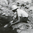
"Armchair prospecting," as I use the term, is a relatively recent method of researching potential mineral deposits using Internet technology such as Google Earth (free at the link here) in conjunction with some of the data resources linked in this blog. Below is an example illustrating how I go about using this method to locate potential gold placer locations.
The following directions are for using Google Earth on a Windows XP computer.
Under "Resources for Prospectors" in the right-hand sidebar of this blog, I locate the link for USGS Mineral Resources On-Line Spatial Data. Clicking on this link takes me to the "Mineral Resources On-Line Spatial Data" main page. Under the heading "Mineral resource data" there is a link titled Mineral Resources Data System (MRDS). Following this link takes me to a page with links to the data files for various mineral resources.
Scrolling down the page to the "Download" section, I find links for downloading data by geographic areas or by "site name, US state, or commodity." Since I'm interested in finding occurrences of gold in Washington, I click on the latter link.
This action takes me to the "Search the Mineral Resources Data System" page where there is a search form containing a number of input and drop-down boxes. I select "Washington" in the "located in" drop-down box and "Gold" in the "with commodity" drop-down box. Clicking the "Search" button, I'm taken to a page which has the same search form and below it a box with the legend, "Choose format." I select "Google Earth" in the drop-down box and click the "Get Data" button.
I'm now taken to a page titled "Package data in KML (for Google Earth) format." There is a box with links for downloading either the full-size "mrds-Washington-Gold-0.kml" file of 5.9 MB or the compressed .kmz version of 189.4 KB. Since either the .kml or .kmz file will work in Google Earth, I choose to download the smaller one (which saves download time and disk space) by clicking the link for the "Compressed data file."
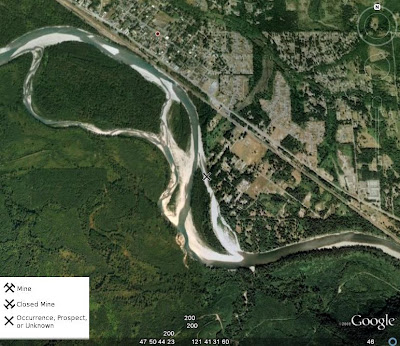
With the data file safely downloaded and saved to a known location on the hard disk, all I need to do is open Google Earth. When it has loaded and is running, I click "File">"Open" and navigate to the the location of the recently downloaded data file. I next select the file (called "mrds-Washington-Gold-0.kmz") and open it. When the file loads, a large number of "X-like" symbols appear over the map of Washington state. According to the legend in the lower left corner of the image, these symbols represent either a "Mine", "Closed Mine", or "Occurrence, Prospect, or Unknown" deposit of the mineral in question -- in this case, gold.
For this example, I choose to center the Google Earth view on Index, a small town in southeastern Snohomish County. Since I'm looking for placer locations, I focus my attention on one of the Xs (that I've circled in red) on the left side of the image below on the Skykomish River near Gold Bar.

Zooming in on my selected symbol, I can see that there are a number of gravel bars on the river in this area.

Any of these bars would be likely spots to try for placer gold. Of course, I would need to determine if there is public access or else arrange permission from private property owners in order to get to the river. I would also need to determine if the locations I am considering are under active mining claim and, if I am interested in staking a claim of my own, find out if the location is open to mineral entry.
If I click on the "X" symbol on my map, I get a pop-up box that contains more information on this particular site, as shown below.

Inside this pop-up box is a link to the record for this site. Clicking on this link will take me to a web page with whatever additional information may be available for this mineral occurrence.
Although the location of this example lies in a relatively developed area, the same method can be used to explore remote wilderness locations.
I hope you have learned something useful from this post and wish you happy "armchair prospecting" sessions this winter that lead to fruitful outdoor expeditions with the return of warmer weather.

3 comments:
Sweet! Thanks a bunch.
You might want to check out MineCache.com. They've used the same MRDS data, and filtered out all the records that don't relate to gold, which makes the data much easier to sift through.
Anonymous,
Thanks for bringing MineCache.com to my attention. I've installed it in Google Earth and find it works quite well. I've also put a link to their website in the "Resources for Prospectors" section.
Post a Comment