The first step in getting MineCache running on your computer is to download and install Google Earth, which may be done by visiting the link in the first paragraph above and following the on-screen directions.
The next step is to download the MineCache.kml plug-in from the MineCache website linked at the start of this post. With Google Earth running on your computer, visit the download link at MineCache.com and, after registering, follow the instructions there. The MineCache folder will appear in the "Temporary Places" folder in the "Places" section of the left-hand sidebar. (When you exit Google Earth, you will be told you have unsaved items in the "Temporary Places" folder. If you want to keep the MineCache plug-in, click "Save.")
Here is a picture of my "Places" sidebar after installing MineCache (and saving it):

As you may notice, MineCache opens with the options "Auto Refresh," "All Gold Claims - MRDS," and "Zoom in closer" checked.
"Auto Refresh" means that as you move the view-port in Google Earth to a new location, after a second or two the display of gold claims will refresh. If you don't want that to happen by itself, select "Manual Refresh" lower in the list.
"All Gold Claims - MRDS" means that the data displayed is from the USGS Mineral Resource Data System; the same data source discussed in my previous articles on "Armchair Prospecting." In the case of MineCache, the data is pre-selected to show gold deposits only.
"Zoom in closer" means that you are too far out to display any gold locations. Use the zoom-in controls in Google Earth to get closer to the surface. Once you are within 100 miles of the ground, you will see a gold dot moving back and forth under the gold claims folder that is selected. This feature indicates that MineCache is checking for records of gold occurrences in the area of the view-port. When the dot stops moving and turns green, it means that the data search is complete. The "Zoom in closer" legend will be replaced with the number of mines, if any, found. Or, in the case of an area with lots of records, it may tell you to zoom in closer still for more results.
Let's take a look at a typical gold producing area near Blewett Pass in Washington:

Activating MineCache in its default mode (described above) results in the display of 58 locations in which gold was found either as the primary or as a secondary mineral:

More information is available about each of these locations by clicking on an icon in the Google Earth image. For example, if we click on the icon for the Bloom Placer (just above and to the right of the image center), a pop-up box appears with information about the deposit:

If we click on the "View more mine details" link inside the information box, a web page opens in the default browser (in this case, Google Chrome) displaying additional data:

Another feature of MineCache is its ability to display BLM mine claim records for both active and closed mines. These data come from the BLM's GeoCommunicator application and are therefore, as BLM warns, not as complete or accurate as the information provided by the BLM LR2000 site. However, as LR2000 data is not accessible via software while GeoCommunicator data is, it is best to use the MineCache BLM information for initial research on an area and, if the results are promising, go to LR2000 directly for the more up-to-date records.
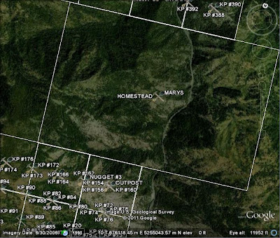
Selecting "BLM Mine Claim Records - Closed" causes the icons previously displayed to clear and new information to show on the screen:

By way of example, clicking on the "Homestead" icon in the center of the screen opens a pop-up box with links to LR2000 information regarding the closed mining claims in this area:

More information about each claim is available by clicking on the "LR2000 MC Report" link for the claim of interest. That is if the link is not broken (as indicated by the red "crosses" at the left end of each data row in the picture) which can happen if LR2000 is down for maintenance or is having some other problem.
Information on active claims is accessed in a similar manner by selecting "BLM Mine Claim Records - Active."
The best procedure is to just install MineCache into your copy of Google Earth and play around with its features. You can also read the tutorial on the MineCache website which gives additional tips and details about the application. The link to the MineCache website is permanently available in the right-hand sidebar of this blog in the section headed "Resources for Prospectors."
Armchair gold prospecting just got a whole lot easier. Have fun!

4 comments:
I've used minecache and it seems like
a useful program. Do you know if there is a way to turn off the labels?
You can un-check the MineCache boxes in the Places folder. That will remove both the icons and labels from the display.
If you mean, is there a way to show the icons without the name labels, then, as far as I know, there is not.
Hope this helps.
Tom - I can't get the claim boundaries to display. Can you help?
Big Man DA,
As far as I know, MineCache does not display the boundaries of individual claims. As pointed out in my follow-up post to the original MineCache story, checking "BLM Mine Claim Records" in Google Earth displays the names of the claims "in yellow boxes outlining the sections or fractions thereof in which the claims are located."
If it's the yellow boxes showing the sections or fractions in which the claims are located that you're not seeing, them I'm afraid I can't help as I just checked my installation of MineCache on Google Earth and it's working normally.
I hope this helps.
Post a Comment