Monday, November 21, 2016

Another New Geologic Map from Washington DNR

granite_falls_thumbnail.png

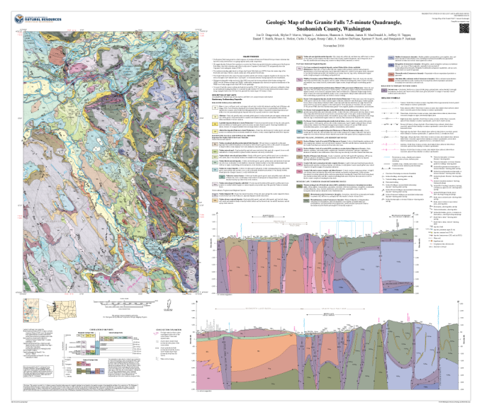
The Washington State Department of Natural Resources has announced the release of a 1:24,000-scale geologic map of the Granite Falls quadrangle.

The new map can be downloaded for free by clicking the map image here.

To see all of the available geologic maps by Washington DNR, visit the link here, which is an online viewer application.

Tuesday, November 15, 2016

Washington DNR Publishes New Geologic 7.5-minute Quadrangle Map


The Washington State Department of Natural Resources has announced the publication of a geologic map of the Shelton 7.5-minute quadrangle, Mason County, Washington.

This 1:24,000-scale map is the latest in the department's efforts to map the entire state at this scale.

The link to the map page online is here.  Clicking on the image will download the map to a .zip folder.

Tuesday, October 4, 2016

The Minerals and Mining Advisory Council and the Rise of the Modernized Mining District


Having written about the revitalization of mining districts in a past post, I was pleased to discover that an organization called the Minerals and Mining Advisory Council (MMAC) has undertaken the task of providing education and support for those miners wishing to organize and modernize the historical mining districts in their areas.

While the process is both more complicated and less straightforward than we might like to imagine, with the help of the MMAC it is altogether doable as evidenced by the fact that as of August 23, the MMAC had at least 30 modernized mining districts with enough pending that they expect to finish the year with about 200 organized mining districts.

In addition to the above figures, the modernized mining districts of the MMAC have so far taken back 5,568,000 acres of federal land to the benefit of the mining community.

In spite of these gains, much remains to be done.  For example, many areas (including Washington state) do not yet have any organized mining districts.  Mining districts, as the MMAC is structuring them, would put an end to such shenanigans as those I wrote about in my last post.

To learn more about the MMAC, their legislative and other initiatives, and how they can help you protect your rights as a miner, visit their website as linked above as well as their Facebook page where they post the latest updates.  And, above all else, get involved.

Let's put mining back in the hands of miners where it belongs.

Sunday, September 25, 2016

Miners Take Note: Plans Afoot to Make Federal Lands in Washington's Okanogan County Permanently Off-Limits to Mining.


According to a news item in Friday's Everett Herald, Senator Patty Murray of Washington introduced legislation in Congress last May to ostensibly, "protect water, salmon and other natural resources in the upper watershed of the Methow Valley."

The bill, which was heard in the Senate Committee on Energy and Natural Resources in Washington, D.C. on Thursday, is titled the "Methow Headwaters Protection Act of 2016" (S.2991) and would withdraw just over 340,000 acres of federal forest land in Okanogan County from "location, entry, and patent under the mining laws."

It appears that, should the legislative assault fail, the Forest Service is concocting an end-run around the existing law by taking administrative steps to shut down Okanogan County mining.  The Herald piece reports that Leslie Weldon, deputy chief of the Forest Service's national forest system and a witness in favor of Murry's bill at Thursday's hearing, plans to coordinate with the Bureau of Land Management in effecting a "temporary" withdrawal from mineral activity of the 340,000 acres in question.

Readers should be aware that these measures are likely only the first in a series, the objective of which is a complete ban on all mining and prospecting activities in Washington State.

Readers should also be aware that these measures are in direct conflict with Title 30 United States Code Section 21a which states, in pertinent part:

The Congress declares that it is the continuing policy of the Federal Government in the national interest to foster and encourage private enterprise in (1) the development of economically sound and stable domestic mining, minerals, metal and mineral reclamation industries, (2) the orderly and economic development of domestic mineral resources, reserves, and reclamation of metals and minerals to help assure satisfaction of industrial, security and environmental needs, (3) mining, mineral, and metallurgical research, including the use and recycling of scrap to promote the wise and efficient use of our natural and reclaimable mineral resources, and (4) the study and development of methods for the disposal, control, and reclamation of mineral waste products, and the reclamation of mined land, so as to lessen any adverse impact of mineral extraction and processing upon the physical environment that may result from mining or mineral activities.

How the "continuing policy of the Federal Government...to foster and encourage private enterprise in the development of economically sound and stable domestic mining, metal and mineral reclamation industries" is served by a complete ban on all mining activities on the public lands administered by the Forest Service and the BLM is a mystery to this writer.  Perhaps Senators Murray and Cantwell (S.2991's only cosponsor), together with Forest Service Deputy Chief Weldon, would care to explain?

Saturday, September 3, 2016

How to Find an Abandoned Mining Claim in 9 Easy Steps


For those interested in having a mining claim of their very own, it helps to remember that claims are sometimes abandoned by their holders or forfeited for failure to comply with the requirements for maintaining them.

If you could get a list of recently abandoned and forfeited claims you might --  with a little research to confirm that no one else has already grabbed them -- find one you could file on and obtain for yourself.

Fortunately, such a list is available from the United States Bureau of Land Management (BLM).  Better yet, you can get it on-line for free.  The BLM even has a free tutorial document that explains step-by-step how to go about customizing such a list to your geographical area of interest.  The link to the BLM tutorial document is:

http://www.blm.gov/lr2000/lr2000pubrpts/FrequentlyQueries/LR2000_How_to_use_action_codes-MC.pdf

As I discovered some differences between the current web pages and those described in the BLM tutorial, I have written out the steps below as I found them at present:

Step 1 - Connect to the LR2000 website at http://www.blm.gov/lr2000.

Step 2 - Click "Run Reports" on the main menu at the top left-hand side of the page.


Step 3 - Scroll to the bottom of the page and under "Public Mining Claims Reports" click "Pub MC Action Code."


Step 4 - On the page that appears, check the boxes for "Action Code," "County," and "Action Date." Then click the "Select Criteria" button at the bottom of the page.


Step 5 - Under "Mandatory Criteria," click the "Set" button next to "Admin State" and then click on the name of the state in the scrollbar box that administers the state you are interested in.  Then click the "Close" button next to "Admin State."  If your state is not listed, it is administered by another state.  States that administer more than one state and those they administer are WY (NE, WY), MT (MT, ND, SD), NM (KS, NM, OK, TX), and OR (OR, WA).  Since I am interested in finding abandoned claims in Washington, I chose "OREGON" as the Admin State.


Step 6 - Also under "Mandatory Criteria," click the "Set" button next to "Action Code" and then click on "631 - CLAIM ABANDONED/FORFEITED" in the scrollbar box.  Then click the "Close" button next to "Action Code."


Step 7 - Under "Optional Criteria," click the "Set" button next to "County" and then click on the name of the county you are interested in from the list in the scrollbar box.  Then click the "Close" button next to "County."  In this case, I chose "Chelan" as the county.


Step 8 - Also under "Optional Criteria," click the "Set" button next to "Action Date" and then click the down arrow at the right-hand end of the drop-down box labeled, "Please select an Operator."  Select "Between" and type the dates in the box labeled "Enter Action Date."  Since the deadline for renewing most mining claims is September 1, enter the two dates separated by a comma. In this example I entered, "09/01/2015, 01/01/2016" to get all the claims that closed between September 1, 2015 and January 1, 2016.  After entering the dates, be sure to click the green check-mark to the left of the box containing the dates to transfer them to the data box below the date entry box.  Finally, click the "Close" button next to "Action Date."


Step 9 - Now click the "Run Report" button at the bottom of the page.


You should see a pop-up box listing the criteria you selected.


If everything looks correct, click "OK" to run the report.  Otherwise, click "Cancel" to make any necessary changes to the information you entered in the previous steps.  If you clicked "OK," you should see a box that says, "Query in process.  Please wait."  After a few seconds the report will appear on your computer screen.  I suggest clicking the "Export to PDF" icon in the menu-bar at the top of the page as doing this will give you the full report as a down-loadable document.


That's it!  You now have a list of the mining claims that were abandoned or forfeited between the dates you entered in the report set-up form.  IMPORTANT:  BLM advises that it can take up to THREE MONTHS for closed claims to appear in their reports.  My advice would be to run reports frequently -- perhaps daily -- beginning on September 1 until at least December 1 to be sure you don't miss any claims.

Now that you know how to harness the power of the BLM's computers to locate potential mining claims, you can turn those otherwise unproductive winter months into a period of fruitful enterprise.  Happy prospecting!

Thursday, April 28, 2016

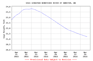
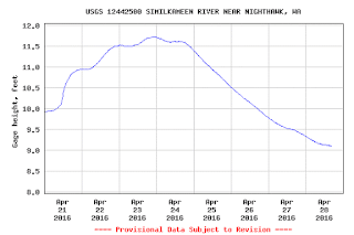
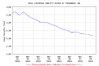
Area Rivers Begin to Recede


Water monitoring stations operated by the United States Geological Survey report declining stream levels around the region.  A few examples, taken from the USGS Current Water Data for the Nation website, show this trend:


Up-to-date data for any of these rivers and many others is available from the site linked above.  Also, in the right-hand sidebar under the heading, "Stream Flow Information," are links to several sites that provide this type of information.  The USGS Water Alert site allows you to set up text or email alerts for various conditions on streams of interest.

With water levels dropping, placer mining season isn't far behind.  Use the resources mentioned above to determine when water conditions are optimal for your planned activity.

Monday, April 25, 2016

Gold, Gem, and Mineral Shows for the Rest of 2016


Following is a list of the gold, gem, and mineral shows in Washington and surrounding areas from May 1 through the rest of the year.  If you're aware of any I have missed, please provide information in the comments.

---------------------------------------------

April 30 10 a.m. to 6 p.m.
May 1 10 a.m. to 5 p.m.

Everett Rock & Gem Club
63rd Annual Gem, Jewelry and Mineral Show

Free Admission
Disabled Access
Free Adjacent Parking

Everett Community College
Walt Price Student Fitness Center
2206 Tower Street
Everett, Washington

More information at www.everettrockclub.com

---------------------------------------------

June 11 and 12 10 a.m. 4 p.m.

GPAA Idaho Gold & Treasure Show

Expo Idaho
5610 N Glenwood Street
Garden City, Idaho  83714

Tickets:  www.goldprospectors.org

---------------------------------------------


June 18-20

Athol, Idaho
44th Annual Northwest Treasure Hunters Club Treasure Hunt

We are going back to Farragut State Park, one of the most beautiful places in the country. For more information, call or email.

Phone: Duncan (208)660-4852; clay (509)999-0692
Email: duncanb73@gmail.com

---------------------------------------------


August 26-28
PNW Miners Rally
Liberty, Washington

Saturday, April 16, 2016

How to Track Down that Elusive Creek, Mine, or Other Feature You've Been Hearing About

“I heard there's coarse gold in [insert name of] creek, but I don't know exactly where it is.”

Have you ever heard anything like this? If you've been in the gold prospecting field for any length of time, you likely have.

Nowadays, instead of poring over numerous maps hoping to get lucky by spotting the name of the creek in question, we have a handy website called Latitude Longitude Search.

Latitude Longitude Search (or Lat-Long for short) lists more than two million geographical locations in the United States. All you need to do a search is the name of the feature you're looking for and the state in which it lies. Hopefully, you know at least this much.

As an example, suppose I'm looking for a stream named “Gold Creek” in Washington. At the top of the site's home page, I type the name into the “Find places named” box, select the state (and optionally the county and/or feature type), and click the “Lat-Long Search” button. I'm presented with eighteen results:


Should I decide to check out the listing in Chelan County, I click on the appropriate blue link in the table. That brings up a page showing the elevation, latitude, and longitude of the location plus its position on two maps: a wide-area map showing the creek's location in the state and a larger, zoomable map showing its location relative to nearby features.


If I want to see more detail, I can switch the larger map to satellite imagery and zoom in on the location.


Hopefully, Lat-Long will help you track down some of the elusive places you've been wanting to investigate.


Questions? Please post them in the comments.

Friday, April 15, 2016

How to Display USGS Quadrangle Map Coverage in Google Earth


Have you ever wanted to locate the topographic map that shows the area you're interested in? If so, you can download a .kml file that will display an overlay in Google Earth that shows the areas covered by the various United States Geological Survey (USGS) quadrangle maps.

The helpful file in question is called QUADS and is available for free from the same people, Metzger-Willard, who offer the PLSS overlay file for Google Earth discussed in the previous post.

Once you have Google Earth – I recommend the Pro version as it is now free at the link here – navigate to USGS Quadrangles and click on the QUADS link in the box near the top of the page. After the file downloads, open it in Google Earth as described in the previous post about the PLSS overlay file.

To use the overlay file, navigate to your area of interest in Google Earth. In the left-hand sidebar of Google Earth, check the “Search Results” box in the “USGS Quadrangles” section. (You may have to expand that section to see the “Search Results” and other option boxes.) Check the “Automatic” radio button under “Refresh Mode” and an overlay of the available quadrangle maps will appear in the Google Earth display.


If you click on one of the colored dots in the center of the various map outlines displayed in Google Earth, a pop-up box will open that gives the name and other information about that particular map.


Clicking the “All maps with this name” link in the box will open a new page in Google Earth with a list of all available maps of the selected area together with their dates and links for downloading them as PDF files.


If you want, you can display a topographic map overlay of the area you are viewing in Google Earth by clicking the “TopoMaps” radio button in the “Overlays” section of the “USGS Quadrangles” section in Google Earth's left-hand sidebar. In my own experience, these overlay maps are not that detailed or useful. I find that downloading the maps I want from the pop-up box links mentioned earlier is more satisfactory.

I hope the information above helps you find the maps you need for your prospecting activities. As always, feel free to ask any questions in the comments section below the post. I will do my best to answer as soon as possible.


Happy prospecting!

Saturday, April 9, 2016

How to Display Sections and Townships in Google Earth


(Note:  This article updates a previous post and replaces the link in the right-hand sidebar section that was lost when the blog was hacked a few years ago.)

----------------------------------------------------------------------------------

If you're conducting research on areas to prospect or working up the legal description for filing a mining claim, one of the things you need to know is where the parcel in question lies with respect to the Public Land Survey System (PLSS).

The PLSS is the easiest way to describe the location of your claim when making out a Notice of Location.  It is also the system used by the Bureau of Land Management (BLM) Master Title Plats that tell you which areas are open to Mineral Entry, meaning, where you are allowed to stake a claim.

This blog has previously discussed some of the ways to use Google Earth as a prospecting aid.  (See Armchair Prospecting with Google Earth and More on Armchair Prospecting.)

The PLSS is available as a convenient overlay on Google Earth.

If you don't already have this handy program, I suggest you download the Google Earth Pro (GEP) version as it is now free.  (It previously cost $399 per year.)  Here is the link:

http://www.google.com/earth/download/gep/agree.html

Be sure to read the system requirements and the note regarding the free license.

Once GEP is installed and running, navigate to PLSS in Google Earth and click on the "download GLSGE" link in the box near the top of the page.  Doing this will download a file named "plss.kml" which you can open in Google Earth by clicking on File>Open in the GEP menu bar and navigating  to where you saved the file (generally the "Downloads" folder).

In "Temporary Places" in the GEP left-hand sidebar, you will find entries for the PLSS overlay application.  Be sure the radio button next to "Automatic" is checked under the "Refresh Mode" section.  To show Sections and Townships, check the radio button next to "Townships" in the "Overlays" section.

You should then see Section and Township borders and labels on your GEP display.  (You may have to zoom in some before they show up.)

The borders and labels will refresh about two seconds each time after you stop moving the map.  As you might find this behavior somewhat annoying, you can switch auto-refresh off by checking the radio button next to "Manual" in the "Refresh Mode" section mentioned earlier.  To return to auto-refresh, just check the "Automatic" radio button again.

Note that sometimes there is a slight difference between where the Section and Township borders appear in GEP and where they actually are.  This means before you do anything important like filing a mining claim, be sure to double-check the border locations with an actual map.  For comparison purposes, below is part of the USGS 7.5 minute quadrangle map of the same area around Blewett, Washington shown in the picture at the top of this article.


When you close GEP, it will ask you if you want to save the locations in your "Temporary Places" folder.  If you click "Yes," the PLSS overlay application will load automatically each time you start GEP.  Otherwise, you can always load the file manually as you did the first time.

I hope you find both Google Earth Pro and the PLSS in Google Earth overlay useful in your prospecting endeavors.

As always, if you have any questions or observations, please enter them in the comments and I will do my best to answer promptly.

Question:  Have you used Google Earth in your prospecting/mining activities and, if so, how did it work out for you?  You can answer in the comments section.

Tuesday, March 29, 2016

More Gold and Mineral Shows Coming in April


Here is a listing I have put together of additional gold and mineral shows for the month of April 2016:

Gem Faire Inc Show

Friday, April 1 from 12 p.m. to 6 p.m.
Saturday, April 2 from 10 a.m. to 6 p.m.
Sunday, April 3 from 10 a.m. to 5 p.m.

Admission:  $7; Children under 11 FREE

Washington State Fair Events Center
110 9th Avenue SW
Puyallup, Washington

More info:  Yooy Nelson (503) 252-8300; email info@gemfaire.com; http://www.gemfaire.com

----------------------------------------------

Yakima Rock & Mineral Club - "Rockin' Your World"

Friday & Saturday, April 8 and 9 from 10 a.m. to 6 p.m.
Sunday, April 10 from 10 a.m. to 4 p.m.

Admission:  Adults $3.50
                    Students $2.00
                    Children under 12 free with adult paid admission
Free parking

Central Washington State Fair Ground
Modern Living Building
1301 South Fair Avenue
Yakima ,Washington  98901

More info:  http://www.yakimarockclub.com/category/shows-events/

----------------------------------------------

GPAA Portland Gold & Treasure Show

Saturday & Sunday, April 9 and 10 from 10 a.m. to 4 p.m.

Tickets:  www.goldprospectors.org

Portland Metropolitan Exhibition Center
2060 North Marine Drive
Portland, Oregon  97217

----------------------------------------------

Idaho Falls Gem & Mineral Society - 52nd Annual Show

Saturday, April 9 from 10 a.m. to 6 p.m.
Sunday, April 10 from 10 a.m. to 5 p.m.

Admission:  $3.00; Children 12 and under FREE

Idaho Falls Recreation Center
Memorial and B Streets
Idaho Falls, Idaho

More info:  https://www.facebook.com/Idaho-Falls-Gem-Mineral-Society-196575797055956/

----------------------------------------------

Willamette Agate & Mineral Society - Annual River of Gems Show

Friday & Saturday, April 15 and 16 from 9 a.m. to 5 p.m.
Sunday, April 17 from 10 a.m. to 4:30 p.m.

Admission:  Adults $2.00; Children under 12 free

Polk County Fairgrounds
520 South Pacific Highway
Rickreall, Oregon

More info:  Contact Etheleen Flippo, (503) 623-4241; email reflippoo@hotmail.com

----------------------------------------------

GPAA Seattle Gold & Treasure Show

Saturday & Sunday, April 16 and 17 from 10 a.m. to 4 p.m.

Tickets:  www.goldprospectors.org

Evergreen State Fair Grounds
14405 179th Avenue SE
Monroe, Washington  98272

----------------------------------------------

Maplewood Rock and Gem Club - Annual Spring Sale

Saturday, April 16 from 9 a.m. to 6 p.m.
Sunday, April 17 from 10 a.m. to 6 p.m.

Admission:  FREE

Maplewood Rock and Gem Clubhouse
8802 196th ST SW
Edmonds WA 

More info:  http://www.maplewoodrockclub.com/events/2016-spring-sale

----------------------------------------------

Lakeside Gem & Mineral Club - 20th Annual Rock & Mineral Show

Saturday, April 16 from 10 a.m. to 5 p.m.
Sunday, April 17 from 10 a.m. to 4 p.m.

Admission:  Adult $5.00 (Good for both days)
                    Children 14 and under FREE with paid adult admission

Benton County Fairgrounds
1500 South Oak Street
Kennewick, Washington

More info:  http://nebula.wsimg.com/b62c54495004e2cf4df38c7122181083?AccessKeyId=930F78DFB2AC575E2B46&disposition=0&alloworigin=1

----------------------------------------------

Mt. Hood Rock Club - 59th Annual Rock and Gem Show

Friday & Saturday, April 22 and 23 from 10 a.m. to 5 p.m.
Sunday, April 24 from 10 a.m. to 4 p.m.

Admission:  FREE (One free rock to each child)

W. P. Jackson Armory
6255 NE Cornfoot Road
Portland, Oregon  97218

More info:  https://mthoodrockclub.wordpress.com/annual-rock-show/

----------------------------------------------

West Seattle Rock Club - 50th Annual Rock Show

Saturday & Sunday, April 23 and 24 from 10 a.m. to 5 p.m.

Admission:  FREE
Free parking

Alki Masonic Temple
4736 40th Ave. SW.
(West) Seattle, Washington

More info:  http://www.westseattlerockclub.org/gemshows.htm

----------------------------------------------

Grays Harbor Geology and Gem Society - 48th Annual Earth Treasures Rock Show

Saturday, April 23 from 9:30 a.m. to 5 p.m.
Sunday, April 24 from 10 a.m. to 4:20 p.m.

Grays Harbor Fair Grounds
43 Elma-McCleary Road
Elma, Washington

More info:  Ken Nelson, (360) 289-0263

----------------------------------------------

Everett Rock & Gem Club - 63rd Annual Gem, Jewelry and Mineral Show

Saturday, April 30 from 10 a.m. to 6 p.m.
Sunday, May 1 from 10 a.m. to 5 p.m.

Admission:  FREE
Disabled access
Free adjacent parking

Everett Community College
Walt Price Student Fitness Center
2206 Tower Street
Everett, Washington

More info:  www.everettrockclub.com

----------------------------------------------

Richmond Gem & Mineral Society - 55th Annual Gem & Mineral Show

Saturday, April 30 from 10 a.m. to 5 p.m.
Sunday, May 1 from 10 a.m. to 4 p.m.

Admission:  A Donation
Free parking

Richmond Arts & Cultural Centre
7700 Minoru Gate
Richmond, British Columbia, Canada

More info:  Lisa Kew; email lisakew@shaw.ca; richmondbclapidary.wordpress.com

----------------------------------------------

Question:  Do you know of any other shows?  If so, please provide information in the comments.

Saturday, March 26, 2016

How to be more effective? Attend Awesome Gold Shows!


Gold shows are a good place to learn about the latest and most effective equipment and techniques for finding and recovering the yellow metal.

Here is a list of shows in our area next month that I want you to be aware of as these are fun and educational events for people of all ages:

April 2-3, 2016
Lacey, Washington

Thurston County Instructional Gold, Gem & Treasure Show

Saturday & Sunday 9:30 a.m. to 5:00 p.m.

Visit the Thurston County Instructional Gold, Gem & Treasure Show for kids and families at the Thurston County Fairgrounds Expo Center, 3054 Carpenter Rd.

Members of the Resources Coalition will be teaching about gold, gold panning, gems and treasure hunting.

Admission:  $5 or bring an unwrapped toy for Toys for Tots.

Call or email for more information.

Phone: (253) 848-8112
Email: pete_n_gwen@comcast.net

-------------------------------------------------------------

April 2-3, 2016
Coeur d'Alene, Idaho

17th Annual Gold & Treasure Show

At the North Idaho Fairgrounds, 4056 N Government Way in the Jacklin Building #25.

See website for details.

Complimentary copies of ICMJ's Prospecting and Mining Journal will be available.

Phone: Bill (206)510-4111; Bob (208)699-8128
Website: http://www.nwgoldprospectors.org
Email: bluefrontside@hotmail.com

-------------------------------------------------------------

April 23-24, 2016
Cashmere, Washington

North Central Washington Prospectors Gold & Treasure & More Show

At the Cashmere Washington Fairgrounds, 5700 Westcott Dr.
Saturday: 9AM to 5PM
Sunday: 9AM to 4PM
Admission: $5, 12 and under are FREE

Gold & Silver Jewelry - Dredge Equipment - Family Fun & Entertainment - Learn how to Pan for Gold - Door Prizes - Rock Hound & Prospecting Supplies - Vendors for all - Gems & Minerals - Lapidary - Gold Pay Dirt - Raffle Prizes - Metal Detectors - Sluice Boxes - Wood Art and Metal Art - Food Vendor

Complimentary copies of ICMJ's Prospecting and Mining Journal will be available.

Phone: (509) 884-3269
Website: http://www.northcentralwashingtonprospectors.com/gold-show/

-------------------------------------------------------------

Question:  Do you know of upcoming shows that should appear in the W. S. Miner?  If so, please tell me about them in the comments.
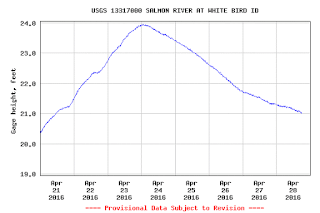
photo credit: Poke of Gold via photopin (license)

Thursday, February 25, 2016

Grab a Cool LIDAR Map of the Chehalis River from DNR...It's FREE

Do you love freebies?  Then take a look at this neat LIDAR* map of the Chehalis River floodplain from Washington State's Department of Natural Resources (DNR).


The map even shows abandoned river channels, a prime place to look for ancient gold deposits, which are often some of the richest.

Grab your copy of the full-resolution map at the link here, or read the original press release from DNR here.

And, as always, be sure to follow the prospecting rules as outlined in the Gold and Fish Pamphlet and don't go onto private property without the owner's permission.

Have fun!

*LIDAR stands for Light Detection and Ranging, which is a remote sensing method that uses a pulsed laser to examine the surface of the earth.  See here for more information.

Tuesday, February 9, 2016

Updating of the Links Section Completed

Housekeeping on the resources for prospectors links section of this blog for the start of 2016 has been completed.  A couple of the sites listed have new web addresses but the only real change is the addition of a link to a downloadable copy of the July 13, 2015 Washington State Gold and Fish Pamphlet.  The new link appears in the "Washington State Prospecting Rules and Laws" section right above the link to the official WDFW page from where the current pamphlet can also be downloaded.

Another change is that the links for obtaining the Tacoma 1:100,000-scale quadrangle geologic map are now working and available in the November 25, 2015 post on that subject.

Once the snow clears, may you have a happy, safe, and prosperous prospecting and mining season in 2016.