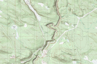
Getting the maps is easy. You just zoom in to your area of interest in "Map" view (which shows a road map), switch to "My Topo" view, and select the topo zoom level you want. Then click on either "Landscape" or "Portrait" next to "Print from your computer:" located below the map image. A new window will open containing your map. The map of Horseshoe Bend on the Sultan River shown below was captured by right-clicking on the map in this new window and selecting "Save image as..." from the drop-down menu. (Note: The real image measures 1800x1200 pixels and is much more detailed than Blogger's scaled-down view shown here.)

The "Hybrid" view button next to the "My Topo" button shows a satellite image with a road map overlay. Both "Map" and "Hybrid" appear to work for anywhere in the world but "My Topo" only displays results for the US and Canada.
For ease of reference, I have added the link to Free Printable Topo Maps to the "Resources for Prospectors" section of the right-hand sidebar.

No comments:
Post a Comment